The Mallakastra Regional Archaeological Project
Fifth Season Preliminary Report[1]
July 20, 2002
The fifth season of MRAP lasted from 22/6/02-20/7/02. Principal objectives of the project in 2002 were as follows: 1) to complete initial study of ceramic finds collected in the field in 1998-2001; 2) to explore the area of the coastal plain that lies between Apollonia and the sea; 3) to conclude environmental studies; 4) and to survey intensively the immediate hinterland of the Illyrian center of Margelliç near the modern city of Patos.[2]
Environmental Studies
See Geoarchaeological Studies Report for 2002.
Archival Research
Research in historical archives supported by MRAP this year explored two avenues. In Venice and in Corfu, Siriol Davies, post-doctoral fellow in the Department of Classics at the University of Cincinnati, sought Venetian records pertinent to the area of Apollonia. Information specific to the Fier area was scarce inasmuch as Venice was never in control of the area included in our survey, although in the late 17th century she did capture Vlora and the nearby fortress at Kanina from the Turks and briefly held them. Of greater relevance to the interpretation of the results of our archaeological fieldwork has been the research conducted by Thurstan Robinson of Oxford University on behalf of MRAP. In the spring of 2002 Robinson examined Ottoman cadastral surveys of the Fier area in the Basbakanlik archives in Istanbul; these date from the 15th to the 19th century. From 1/7-5/7 he studied original Ottoman documents in the Albanian state archives in Tirana and photocopies of other Ottoman documents in the collection of the Institute of History in Tirana. We anticipate that there will result from his work a rather complete history of settlement in the MRAP study area for the past five centuries.

Figure 1. Map of Kryegjata Tumulus Cemetery with Confirmed Tumuli Indicated by Dots
The Necropolis of Apollonia
Inspection of the contour map prepared using a Total Station by Galaty and Newhard in previous seasons reveals small topographic anomalies, which arguably reflect the existence of artificial burial mounds. For two days (8/7-9-7/02), Galaty, Korkuti, Davis, and Holden, visited these places in the field, and Korkuti determined if they actually represent the remains of such tumuli.
Survey Between Apollonia and the Sea by Team P
The area between Apollonia and the sea has not, to the best of our knowledge, previously been the target of any systematic archaeological investigation, although casual discoveries, published and unpublished, that have occurred in this area are well-known to local archaeologists. Much of this area was a vast marsh before being drained in the last century through the construction of an intricate system of canals. The land is now well-cultivated, but much lies at an elevation lower than one meter above sea level. There are only a handful of villages west of Pojan, and these tend to be located on isolated areas of slightly higher ground: viz. Sopi and Povelc, the former near Pojan, the latter consisting of Hoxhara and Derzezë at the present mouth of the Vjosë.
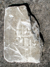
Figure 2. Inscription from Site 043. SF3035.
This area was investigated by Team P under the direction of Lorenc Bejko during the first two weeks of the season. The work consisted of three separate activities. In the first place one long transect established by differential GPS was walked from Apollonia to the sea, a distance of ca. 8 kms. It began at the highest point of the upper acropolis of Apollonia and proceeded westwards through the main entrance to the city. The purpose of this transect was both to determine if there existed any surface artifacts in this area and to determine where the western edge of the site of Apollonia lay.
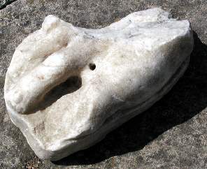
Figure 3. Site 043. Foot from Marble Statue. SF3036.
A second east-west transect was established parallel to this long transect and ran westwards from the position of Leon Rey's house on the lower acropolis. It was discontinued once a fall-off in surface artifacts was reached that arguably marked the edge of the city (at approximately 800 m. from the city walls). These east-west transects in part and two north-south transects perpendicular to them within the walls of the ancient city of Apollonia served also to provide us with a sample of artifacts that can be compared with those in the hinterland of the city-state and with collections from the acropolis of Margelliç (see below).
Three areas in the plain were also earmarked for special investigation. In one place, about 800 m. outside the city walls, Selim Islami in the late 1950s had explored the apparent remains of a "Roman temple" dedicated to Demeter and Kore, after a tractor had turned up female figurines, some of them naked and said to be erotic. (These have not been published.) We were told that later, in the 1990s, the construction of one of several houses in an agricultural complex revealed the foundations of the temple.
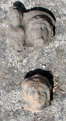
Figure 4. Female Figurines from Site 043.
Our team defined and walked normal tracts around the house (Tracts P-131—134), in the course of which they found, in addition to pottery, the foot of a statue, a late inscription in Greek, and a small stone altar. The collection of this locality as Site 043 produced Archaic, Archaic-Classical, Classical, Late Classical, Hellenistic, Early Roman, Middle Roman, Ottoman, and modern pottery as well as many female terracotta figurines.
Team P also investigated the environs of the village of Boçova (literally "empty plain" in Turkish), between Apollonia and the Lagoon of Nartë (Tracts P-184—193). The present village is located on what is obviously an old ox-bow in the Vjosë River. A certain amount of pottery was found in and around the cemetery of the village, including Ottoman and Modern. The oldest graves in the cemetery are similar to the so-called "Ottoman" graves in the old cemetery at Radostina. Local traditions report that Austro-Hungarian soldiers were buried here. In addition, Team P surveyed around the old bed of the Vjosë at Kurrizet e Sopit (Tracts P-120—130), where substantial quantities of HL, ER, and MR pottery was found. Finally, Team P collected two predominately Paleolithic sites that had been defined already in 2000, one at Peshtan (S036), the other at Kraps (S039). In total the team defined 193 tracts, with a total area of ca. 0.6 sq. km.). Those in the transects were rectangular, within the city walls 50 m. long, and 100 m. long outside the walls. Other tracts were defined normally so as to coincide with natural units of vegetation and visibility.
Survey by Teams L and M in the Plain West of Apollonia
In 2002 Teams L and M, led by Wayne Lee and Charles Watkinson respectively, divided their work between two regions. The first three weeks were spent surveying the countryside around Margelliç (see below). Because of the success of Team P in surveying in the area between the walls of Apollonia and the sea, it was then decided that in the last week of the project these teams should expand our investigations in the plains west of Apollonia, particularly around the villages of Pojan, Sopi, and the hamlet of Islamaj.
Team L began by making a long sweep of tracts just outside the ancient city walls and between the two main irrigation canals. Survey in that whole strip documented the existence of heavy scatters of artifacts of mostly Hellenistic date. A rescue excavation in 1962 had identified a portion of this area as the "west cemetery" of Apollonia (MRAP Site 049).[3] Team L's finds could in part be associated with the cemetery, which itself probably reflects the existence of the road out of the main gate of the ancient city, a housing district outside the city walls, or simply trash thrown out from the city.
Somewhat further west, beyond the two main irrigation canals, Team L surveyed a large area south of Pojan, surrounding Sopi, and including the hamlet of Islamaj. The modern landscape is heavily irrigated and cultivated, with major irrigation ditches running parallel to each other, generally 200 meters apart. Fields run perpendicular to the ditches, and are generally narrow (a given crop strip might be only 15-30 meters wide, exceptions being the large fields of fodder and hay). Further west, beyond where Team L worked but covered by some of Team M's tracts, fields become much larger and less variegated. Pottery densities in this region were more variable than in the strip close to the ancient city walls, but artifactual distributions remain continuous for at least 0.5 km from the walls.
At the extreme northwest edge of the area covered by Team L we surveyed an area that contained the hamlet of Islamaj, which earlier in the year had been designated as Site 043 Team P (see above). Our tract walking suggests that the site may be much more extensive than supposed by Team P, perhaps as much as 500 meters wide. It may even include a dense and seemingly more bounded area of Hellenistic material found to the southeast (Tracts 401 and 403).
Finally, south of Sopi, Team L discovered a very long (700 meters) heavy scatter of Ottoman pottery (Site 048). As we worked those tracts we also noticed a series of small (house-sized?) bare spots in the vegetation that may indicate subsurface disturbances or the presence of house foundations. It may be that Sopi is in fact a very old village, and was once much more extensive than it is today.
Team M started working north of Pojan and gradually moved south to meet Team L in the area of Islamaj. Working further from the ancient city, Team M did not encounter the continuous high densities described above but instead was able to define some more discrete concentrations. These seem to fall into two major categories, perhaps reflecting a distinction between Hellenistic tile graves and settlements.
Likely tile graves consisted of small concentrations of artifacts less than 30 m x 30 m across, noticed by only one or two walkers and consisting predominantly of highly diagnostic tiles sometimes mixed with finewares (Tracts M-405 and M-406; M-438 and M-439; M-411 to M-413; M-433 to M-434 [said to have been associated with bones when first plowed]). Settlements consist of larger concentrations ranging in size from possible farmsteads like S047 to larger sites like S050. As well as tiles, coarsewares are common at these sites. A fragmentary tile, found in one of these concentrations (Tract M-454) is stamped in Greek letters in a rectangular frame with the name FALAKRIWN, an exact parallel to an impression on a tile found at the 1st-3rd C BC necropolis of Gërmenj, east of Divjaka.[4]
Ottoman material was also found by Team M, although not in such extensive concentrations as those noted by Team L at S048. An intriguing pattern was the association of Ottoman ceramics with high densities of Hellenistic material. Such a correlation in findspots may reflect micro-topographical variation in the pre-drainage landscape of this lowland area: i.e., in both periods sites at higher elevations were preferred.
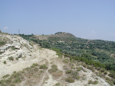
Figure 5. View of the Upper Akropolis at Margelliç from the Area of the Ancient Cemeteries at Margelliç.
Survey at the Illyrian City of Margelliç
Archaeological remains at Margelliç were first described by the Austrians, Camillo Praschniker and Arnold Schober at the beginning of the 20th century, but were first systematically explored by Neritan Ceka in the early 1980s.[5] Margelliç consists of a high acropolis surrounded by a fortification wall of polygonal blocks. Ceka's excavations revealed uncovered buildings of the 7th-4th century B.C. in one area, and of the 3rd-2nd century B.C. in another. In another part of the site he explored a prehistoric wall and associated levels of the Late Bronze Age. A grave in the cemetery contained a Mycenaean pyxis of the LH IIIA style. Our own goals were to define more closely the limits of the site outside the city wall and to describe the types of patterns of settlement that were here characteristic in the countryside. Our more general purpose was to collect data that would permit us to compare the material culture of Margelliç, an Illyrian city, with Apollonia, a Greek colony, only 25 kilometers from it.
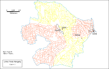
Figure 6. Distribution of Lithics in the Area of Margelliç
Teams L and M worked together in an effort to encircle the citadel of Margelliç (Site 041) and gather data on settlement patterns surrounding the ancient city. The 4.42 sq. km. that were surveyed allow some preliminary patterns to be observed. In addition to the acropolis of Margelliç itself and its immediately adjacent slopes (S041 and S045), two sites were defined in this area, one likely to be a small Hellenistic farmstead (S044), the other a large Paleolithic site (S046).
The success of MRAP in identifying Paleolithic sites was repeated this year with the discovery of S046, Rusinja, on a low ridge with panoramic views to the east of Margelliç. The large chert cobbles eroding from dark red soils at this site may explain the very large size of many of the Mousterian tools collected during survey in Tracts M-252 to M-264. Teams L and M both found lithics scattered across their areas with dates ranging from Lower Paleolithic to Mesolithic, with a further light concentration on the western slope of a steep ridge heading southwest from Margelliç.
Later prehistoric finds were confined to the areas at the bottom of the valley near Rusinja where streams may have washed material from higher up. It is difficult at present to distinguish any areas of later prehistoric concentration distinct from S041 itself.
For the landscape of the historic past, it is easiest to begin with the negative evidence in the area surveyed last. It seemed clear fairly quickly that much of the area to the south of the ancient city is devoid of significant evidence of settlement. A large ridgeline runs almost directly south from the Margelliç plateau; Team L surveyed to the east of it, and Team M to the west. Neither team reported any significant concentrations (with the large exception of modern fragments of large clay jugs used by the oil industry to contain acid to aid in drilling through alkaline rock). Parts of the region were heavily overgrown and quite steep, but there is also an extensive heavily cultivated rolling area that nevertheless was surprisingly empty of artifacts. What material we did find tended to fall into either the Hellenistic or modern category; small concentrations in tracts around M-298 may come from tile graves.
The first Team L area was immediately to the east of the ancient citadel, and stretched away toward Rusinja and the valley bottom to the northeast. Here there were many more finds, including a dense Hellenistic scatter of pottery and tile at the foot of the citadel cliff that became Site 045. Here we also found a small paleo-Christian altar, and a fragment of a Hellenistic cippus/kioniskos. The smaller ridges and gullies spreading out from that location toward the valley bottom and Rusinja had a fairly continuous and occasionally heavy scatter of Hellenistic material. As one moved further east and closer to Rusinja, the finds became much more multi-period, from Bronze Age through Ottoman (including Roman, and even a bronze Roman fibula).
The first Team M area with material of historic interest is on the eastern side of the valley (east of Margelliç), near the village of Rusinja. Topographically this region consists of a series of ridges running down from the south and east sides of the valley. Hellenistic material was discovered all along the east side of the area, below the Rusinja ridge (S046) but the major concentration was on a ridge running north from the asphalt Ruzhdija / Margelliç road. Designated S044, this area of Hellenistic tiles and coarsewares included a millstone fragment that seems clearly to distinguish it as a settlement site. A continuous spread of Hellenistic, Roman and earlier material just to the northwest was found by Team L in tract-walking. To the west of this ridge a small concentration of Hellenistic finewares was possibly in situ.
The second L Team area consisted of a region in the area north and west of the citadel. This is very rugged and steeply dissected, and areas at higher elevation areas are heavily eroded. We in fact started referring to the radiating ridgelines as "the fingers." Two of those ridgelines (the one pointing north, and the one pointing west) have modern cemeteries at the highest points, and apparently ancient ones as well. On the western ridgeline we found a high and continuous density of Hellenistic material for 500-600 meters out from the modern village. Finds included an amphoriskos found in situ, which was excavated and reconstructed almost in its totality. Adjacent to the amphoriskos was evidence for a cut-stone grave, with the outline of a skull still in situ, all exposed by a bulldozer, probably during bunker construction). Just north of this location (on another "finger") we found evidence in several tracts for yet more Hellenistic graves, including a tombstone (identified by Skënder Muçaj), an unbroken fusiform unguentarium, and finewares in association with bones. The evidence for an ancient cemetery on the ridge running north from Margelliç is less clear, but we did find another fusiform unguentarium there, nearly identical to the one found to the west. Other than these three possible, even probable, cemetery locations, the area northwest of the village was relatively bare of artifactual material.
The second main area surveyed by Team M (to the west of the citadel in the valley bowl to the southwest of Patos Mustafa-Matohiti) revealed much less Hellenistic material with no clear concentrations. The occasional large fragment of tile in the center of a field continues to provoke questions about the distribution of this class of material. Small scatters of Ottoman material reveal that this rich agricultural landscape was never barren, but may well have been dedicated to fields rather than houses.
Moving finally to the Ottoman and even more modern periods, Team L and Team M both encountered a large amount of recent material in this densely occupied area: the modern villages of Margelliç and Patos (Mustafa-Matohiti) present an almost continuous semi-circle of settlement west of the ancient citadel, while there are occasional outlying farmsteads along the main roads. The small village of Rusinja defines the northeastern limit of the survey area, while yet another Patos marks the southern edge of the survey area. The Patos toponym "Mustafa Matohiti" reflects some of the more dramatic events in the area's recent history: this partisan hero was involved in the successful destruction of a German armored vehicle before being killed in this region in 1944 and this event is commemorated on a monument on the road between Margelliç and modern Patos. Team L encountered a less formal, but no less powerful, memorial to World War II in the form of a German army helmet, rusted through only at the top.
The entire region is dotted with oil pumps and drilling rigs, many of which continue to pump oil, often spilling large quantities onto the surrounding ground. There are innumerable small roads hastily cut to access the pumps, many of which are now washing out as those sites fade from use. Oil storage tanks and associated production buildings also dot the landscape, with many of the latter now destroyed. The shifting location of active oil fields apparently explains the existence of various villages known as Patos, a new incarnation being built as new sections of the oil fields came into production from the 1920s onwards.
The whole area is extensively cultivated as well, with even some very steep slopes being used for olive trees. Olives are in fact probably the most common crop (by area of coverage): young trees are being planted and there is a modern olive press on the road from Margelliç to Rusinja. There are also many market gardens close to the villages, as well as maize fields. There is not, however, any sense of pressure on the cultivable area. There are many fields with only scattered cultigens, and other fields which, if cleared, could be planted. Evidence of private efforts to do just that were particularly obvious in the southern area.
Museum Studies
As in previous years Sharon Stocker and Skënder Muçaj directed operations in the museum. Marion Parker and Maria Grazia Amore assisted with the processing of artifacts. Muçaj was responsible for the preliminary analysis and dating of ceramics. Both Garett Holden, the project photographer, Ilir Zaloshnja, project illustrator, and Jack Davis, serving as a second illustrator, operated in conjunction with the museum. Muzafer Korkuti and Arta Mëhilli examined new lithic finds and collected metrical data for lithic artifacts collected in previous seasons. Nermin Mërtiraj photographed lithics for several days. Procedures followed in the museum were as established in previous years (see earlier reports).
Some 18,500 sherds and small finds were processed and catalogued during the 2002 season. 16 sites (S019, S026, S027, S031, S032, S033, S035, S036, S037, S039, S040, S041, S043, S044, S045, S047) collected during the 2000, 2001, and 2002 seasons were also processed, as were finds from ten trenches excavated at S034, the analysis of which had not been completed in 2001.
Several striking patterns in the distribution of artifacts have emerged as the result of the study of artifacts this season. Paleolithic finds were less widely distributed in areas surveyed in 2002, both around Margelliç and in the plain west of Apollonia, although S046, northeast of Margelliç, may well be the largest, densest, and best preserved site found in five years of survey. Artifacts of the Bronze Age and Early Iron Age, although not plentiful, were much more frequently found in the area of Margelliç than in any other area surveyed in 1998-2002.
The preceding observation would appear to provide support for the notion that here, unlike at Apollonia itself, there were native Illyrian settlements that were gradually Hellenized through contact with Greek settlements. Greek ceramics reached Margelliç as early as the Greek Archaic period, although they were not plentiful in the countryside until Hellenistic times. As a result of adding the area of Margelliç to the area surveyed it is now also possible to see for the first time that there exists no simple linear falloff in Greek ceramics with distance from Apollonia. Instead, some areas that are relatively close to Apollonia, such Peshtan, have produced comparatively little in the way of Hellenistic pottery, whereas others, such as Margelliç, which are at a considerably greater distance from Apollonia, have yielded far larger quantities.
Finally, as a result of survey in the plain west of Apollonia, on the acropolis of Apollonia itself, and at Margelliç it is now clear that our failure to find significant quantities of Roman pottery in previous seasons did not result from any failure to recognize it, where present. Significantly it now is clear that, unlike in the uplands east of Apollonia, on the acropolis of Apollonia and in the plain to the west of the site, dense Hellenistic occupation was followed by an extensive phase of Roman settlement and land use.
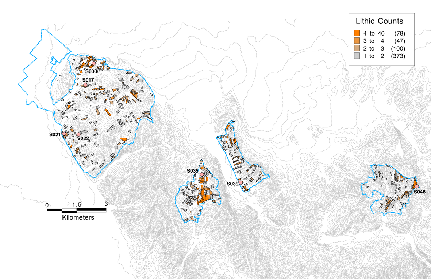
Figure 7. Distribution of Paleolithic Artifacts in the Area Intensively Surveyed 1998-2002.
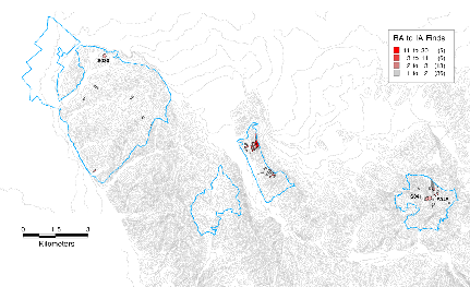
Figure 8. Distribution of Prehistoric and Iron Age Artifacts in the Area Intensively Surveyed 1998-2002.
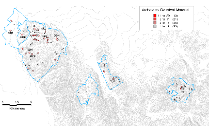
Figure 9. Distribution of Archaic and Classical Artifacts in the Area Intensively Surveyed 1998-2002.
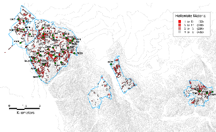
Figure 10. Distribution of Hellenistic Artifacts in the Area Intensively Surveyed 1998-2002.
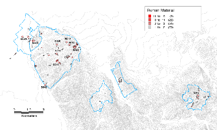
Figure 11. Distribution of Roman Artifacts in the Area Intensively Surveyed 1998-2002.
Ca. 34 samples of tiles from S034 (SF2866, SF2870, SF2871, and SF2873) were exported in July by DHL courier to the Demokritos Institute in Athens, to be analyzed under the care of Yiannis Maniatis, director of its Archaeometric Laboratory. These consisted of overfired tiles, normally fired tiles, and several tiles that appeared to be unbaked (see the 2001 report). In addition to tiles, eleven samples of volcanic stone artifacts were exported to the University of Cincinnati so that their sources may be identified.[6]
Catalogue of Sites Defined or Collected in 2002
S035. PL?, A, HL, O, I, C, M. Ca. 2 ha. Tracts F-043—052. Peshtan Binjakët. In the Peshtan valley ca. 1 km S of the Cakran/Peshtan road junction. A small knoll with 4-5 house complexes on it.
S036. MPL, UPL. Ca. 1.8 ha. Sheshi i Gushallareve (Fusha e Madhe). Tracts F-223—227. A broad-saddled ridge extending W down from the Cakran road.
S039. LPL, MPL, UPL, HL. < .5 ha. Located near the village of Kraps. Associated tracts include H-347—349, H-352. According to M. Timpson, the knoll on which the site is located is one of several abandoned river terraces. A- and B-horizons sit on top of river gravels. In 2002, we learned that the top few meters of the knoll had been stripped to construct the dam that holds back the water for a nearby pond/reservoir.
S040. CL, HL, O, M. 0.7 ha. Tracts K-034—037 on the saddle of a hill about 500 m. SE of Cuka e Bukur. Remains of an ancient farmstead?
S041. LBA, IA, A, CL, HL, MR, LR, EB, MB, O, M. Ca. 2 ha. Margelliç Kalase. SE of modern village of Margelliç. Previously excavated by N. Ceka. Small acropolis, with prehistoric, Hellenistic, and Medieval fortifications.
S042. EIA, HL, R, O. Excavated Roman villa at Levan. Tract C-289. Roman water pipe discovered in Tract C-277 during revisit in 2000.
S043. A, CL, LCL, HL, ER, MR, O, M. Ca. 0.75 ha. Sanctuary of Demeter and Kore. Near Pojan, west of the canal at the western edge of the village. Within a complex of farm buildings, first established in the 1930s, and belonging to the Binyakët family. The area has a higher elevation than the plain as a whole. According to an older member of the Binyakët family, Skënder Anamali and a Russian woman conducted excavations here in 1957-58. In 1996, when a new house was built, foundations of a building with large regular blocks were uncovered.
S044. 1.0 ha. HL, LB. Tracts M-042, M-043, M-048 and M-049. Small HL settlement, possibly a farmstead, with possible later re-occupation on the W side of the ridge.
S045. 0.6 ha. HL (possibly MHL), LR, possibly also MHL and IA. Tracts L-080, L-089, L-090. At the foot of a cliff immediately to NE of S041 (Margelliç Kalase). Substantial military constructions around the site, especially to N and W. Some material from this site must be eroded from S041 above.
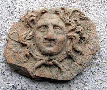
Figure 12. Hellenistic Applique Head of a Gorgon from Site 045.
S046. PL, HL. 3 ha. Tracts M-252 to M-264. On a low ridge to E of the Margelliç acropolis (S041). The PL is concentrated on its highest point. Roads have cut through well-preserved soils with a dark brown A horizon and a dark red B horizon exposing the red B horizons. It is in the latter that the lithic concentrations are found. The HL is a small concentration above the Rusinja road.
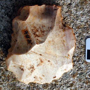
Figure 13. Large Levallois Flake from Site 046.
S047. HL, O. 0.8 ha. Tracts M-347 and M-348. Small, largely HL site on the plain near Pojan Islamaj.
S048. O. 1.5 ha. Associated with Tracts L-471-497. On the plain, south of Pojan-Sopi.
S049. HL, R. 1-2 ha. Western necropolis of Apollonia. Immediately south of the village of Pojan, between the two main irrigation canals and just to the west of the western canal. Excavations by A. Mano in 1962 were conducted in L-385, according to Vangel Dhimo. (Note: Tract 385 had very low visibility in 2002.) The necropolis must be approximately associated with Tracts L-313-366.
S050. HL, O? Associated with M-368 to M-370 and M-384 to M-387. Very large concentration of HL (and later) material, located on the plain directly west of Apollonia.