The Mallakastra Regional Archaeological Project
Geosciences 2002
M. E. Timpson and S. B. Yazvenko
The geoscience program for 2002 had two primary goals: 1) to follow-up on palynological investigations initiated in 1999 and 2000, and 2) to integrate soil and geological observations with the archaeological survey program in the Margelliç area. Additional activities that developed through the course of the field work included the initiation of a lithic source study of the volcanic mill stones recovered from a variety of site locations over the course of the project and site-specific soil/geological observations at a number of sites that were the object of archaeological site-collection activities.
Palynological Research
Palynological research focused on three areas that were initially examined in 1999 and 2000. The object of this year’s work was to recover cores from sites closer to Apollonia than the lagoon at Nartë (where an 11 m. deep core had been taken in 2000), and to ensure that critical developmental periods in the history of the area of Apollonia were covered by cores: in particular, the time of the foundation of the Greek colony, the transition from Greek to Roman rule, and the period of the Ottoman conquest. New cores were collected from the former marsh at Mbrostar, the extant wetland complex at Roskovec, and the small lagoon at Kërrnicë, west of Povelc, near the shore of the Adriatic. Test coring at Mbrostar and Roskovec in 2000 yielded promising dates and sufficient pollen concentrations to warrant further study, provided an appropriate coring device could be utilized. A core collected from Kërrnicë in 1999 demonstrated that deposition in this area had been extremely rapid over the last 500 years. We returned this year with a Hiller coring device that facilitated the collection of vertically intact cores in the heavy-textured, partially drained sediments at Mbrostar and the floating peat and lacustrine sediment sequence at Roskovec.Mbrostar
The former wetland complex at Mbrostar has been drained for agriculture by a series of open ditches up to 1.5 m deep. Due to the effects of drainage, we used a Dutch soil auger to core approximately 1.3 meters below the base of one of the larger drainage canals before collecting any pollen samples. Sediments below this depth did not appear to be influenced by oxidation resulting from drainage activities. We collected a 3-meter-long core (extending from 2.75 to 5.75 m below the current land surface) from a location approximately 1 kilometer east of the location that was sampled in 2000. A number of zones in this year’s core contained well-preserved plant remains that were sampled for 14C dating. The lower portion of the core will be dated using bulk sediment samples due to the lack of visible plant remains. Test coring conducted in 2000 yielded a 14C date of about 2000 BP (uncalibrated) from a sample about 3 meters below the present land surface. Since the core collected this year begins at about the same depth, we expect the new core to yield data covering a portion of the late Holocene (ca. 2000 - 4000 BP, based on the sedimentation rate determined from the 2000 core). Although we will not have any data covering the last 2000 radiocarbon years, the core will allow us to correlate local variation in vegetation communities with the same time period in the Nartë core (which should provide a regional picture of paleoecological conditions). The core will also provide a “snap-shot” of the ecology of the Seman River floodplain during this period, adding to the information already provided by Eric Fouache’s research (Fouache et al., 2001). Roskovec Test cores from Roskovec collected in 2000 yielded stratigraphically correct dates of 1425 AD cal. (at 2.5 m below the surface) and 105 AD cal. (at 3.6 m below the surface). Based on these dates, it was apparent that further coring in this location, with the right equipment, could yield a picture of the paleoenvironment over a relatively long period of human occupation in the vicinity of Margelliç. The local record from the core at Roskovec, like the core at Mbrostar, can also be correlated with the regional record from Nartë. The wetland at Roskovec consists of a floating mat of peat overlying a sequence of clay-rich lake deposits. The 4.3-meter-long core retrieved in 2002 was located within a meter of one of the test cores collected in 2000. Pollen and 14C samples were collected from the lower part of the peat mat and throughout the sequence of clayey lake deposits. Several high-quality organic materials were sampled for 14C dating, including two mineral-peat-mineral sequences, indicating that the lake dried up and became a marsh (like it is today) at least twice during the time period covered by the core. These environmental changes may be related to paleoclimate or anthropogenic effects, but at this early stage of analysis these are only hypotheses.Kërrnicë
In 1999, a 4 to5 meter-long core was recovered from the lagoon at Kërrnicë. Carbon dating of sediment from the base of this core yielded a date of 1445 to 1645 AD (calibrated). This date range covers at least a portion of the Ottoman period in the Apollonia area. Based on this result, and the fact that the 1999 core has deteriorated in storage, we decided to collect an additional core from Kërrnicë. Initial coring was begun on the west side of the island located at the northern end of the lagoon, in close proximity to the core collected in 1999. The first meter of this core consisted of very sandy mud deposits, that are not favorable for pollen preservation. The core terminated at about 1.8 meters on a relatively dense sand layer. We abandoned this core and began probing the lagoon for a more suitable core location. Extensive test probing indicated that the sand layer that terminated core 1 was rather continuous throughout the lagoon at a depth of 1.8 to 2.5 meters. Based on this information, we chose a second core location approximately 15 meters off the southern tip of the island in 1.5 to 1.7 meters of water. We recovered a 2.5 meter-long core from this location. The sediments consisted of dark gray, reduced estuarine muds (silty clays). Plant remains collected for dating should yield reliable 14C dates for much of the length of the core. The bottom date will be based on a bulk sediment sample due to the lack of visible plant remains. Although the 2002 core from Kërrnicë is only about half as long as the core collected in 1999, it is possible it may represent the same time interval as the 1999 core due to the highly variable nature of sedimentation in the Kërrnicë area. Rapid and variable sedimentation conditions in the Kërrnicë area could result in very low pollen densities, thereby reducing the reliability of the analyses. If pollen densities are too low, palynological analysis of the core may prove useless. Additional paleoecological data can be recovered from this core through the analysis of the diatom remains. Diatoms are microscopic zooplankton whose skeletons are composed largely of silica. These organisms live in marine, brackish, and freshwater environments and are excellent indicators of water chemistry and aquatic environment. If the pollen yield from samples collected at Kërrnicë is too low for reliable palynological analysis, it would be more useful to examine the diatom record. If both records can be investigated, a clearer interpretation of the paleoenvironment of the lagoon would result. With the completion of fieldwork in 2002 we feel reasonably confident that we will have at our disposal pollen analyses for the Neolithic and later periods from Nartë, and for the past two millennia or more from the cores taken this year from locations closer to the site of Apollonia[1].Soils and Geology Near Margelliç
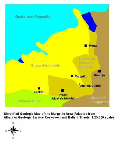
Figure 1
The archaeological survey area surrounding Margelliç is underlain by sedimentary rocks dating to the Pliocene and Miocene. These rocks were deposited at a coastal margin in near-shore and offshore environments. The village of Rusinja is underlain by an upper Miocene deposit that consists of mudstones, sandstones, and gypsum deposits [Figure 1]. The first area surveyed by Teams M and L is separated by a geologic contact between this Miocene deposit and an unnamed Pliocene deposit that underlies a part of the citadel of Margelliç. The contact between these two geologic units continues northward and extends to the large reservoir north of the village of Kuqari. The main village of Kuqari is underlain by rocks of the Rrogozhina Suite, an upper Pliocene deposit consisting of conglomerates, sandstones, marls, and calcareous mudstones, and straddles the contact between the Rrogozhina Suite and the unnamed Pliocene deposit mentioned above. The village of Margelliç is underlain by Rrogozhina Suite rocks and is located close to the contact between the Rrogozhina and the unnamed Pliocene deposit. The citadel at Margelliç straddles two Pliocene deposits, the unnamed unit that appears to consist largely of marls and fine-grained sandstones (based on personal observations of road cuts), and the Rrogozhina Suite. The Rrogozhina Suite is the same group of sediments that underlie the Apollonia survey area. The village of Patosi (Mustafa Matohiti) is underlain by the unnamed Pliocene deposit. These rocks extend westward to just east of the village of Rrërësi where the deposits transition back to the Rrogozhina Suite. Southwest of Rrërësi, the Rrogozhina Suite transitions to an older Pliocene formation, the Helmesi Suite. This formation is composed of mudstones, siltstones, and sandstones. Two days were spent walking with the archaeological survey teams in areas north and west of the villages of Margelliç and Patosi (Mustafa Matohiti) to assess the soils and landforms in that part of the survey area. The initial survey area around Rusinja was not examined this year due to scheduling conflicts. The ridges and valleys below Patosi (Mustafa Matohiti), covered by Team M, consist of soils formed in residual bedrock of the unnamed Pliocene formation and alluvial fill material deposited in the larger stream valleys [Figure2].
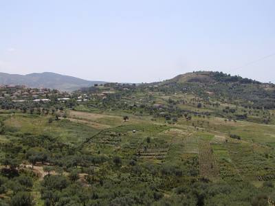
Figure 2
The soils on the ridge tops and side slopes are moderately eroded, with most agricultural activities occurring on red-colored B-horizons. Footslopes and valley bottoms have received significant quantities of sediment from higher lying areas. Artifact distributions in this area have been impacted by both erosional and depositional processes. Smaller artifacts are likely to have been transported down slope and buried by subsequent depositional events, whereas larger artifacts may be left behind on ridgetops as an erosional lag. Careful interpretation of the artifact distributions in this area is required, because even small concentrations in upland areas may be significant. Given the degree of deposition in the valleys, surface survey is unlikely to identify much evidence of past occupation in these locations (see the archaeological report for the results of survey in this area). The highly dissected ridges north of Margelliç, surveyed by Team L, are underlain by Pliocene Rrogozhina Suite rocks. This area was once covered by thick, Terra Rossa soils, as evidenced by scattered remnants on ridge tops and side slopes [Figure 3].
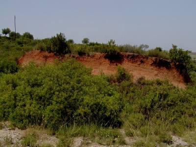
Figure 3
Soils and geology in this area are similar to the Terra Rossa soils surrounding Apollonia. The majority of Terra Rossa soils formed in coarser-textured deposits (sandy and gravelly sediments) that contained abundant crystalline limestone fragments (as at Kryegjata B and the quarry at Radostina). Road construction for early oil field development has resulted in accelerated erosion that has denuded large portions of this survey area [Figure 4].
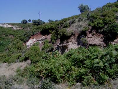
Figure 4
A few, isolated patches of intact soil (A-horizons were 15 to 20 cm thick) were noted in this area, but most soils were truncated, with modern vegetation growing directly in eroded B-horizons [Figure 5].
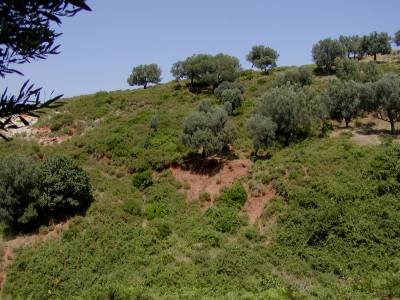
Figure 5
Erosion and deposition have influenced the distribution of artifacts in this area too. Erosion of the ridge tops has transported artifacts down slope, but it has also led to deposition of significant (0.6 - 1 m) amounts of red soils on lower lying, shoulder and backslope positions, thereby masking artifacts in these locations [Figure 6].
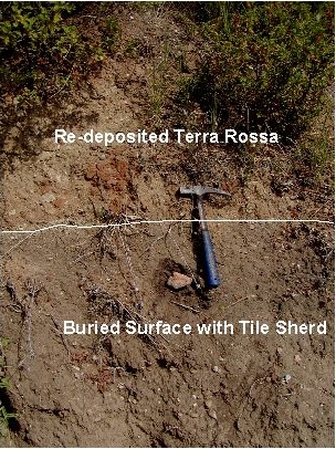
Figure 6
So, there are two geomorphic factors affecting artifact distributions in this part of the Margelliç survey area; loss of soil from the ridetops, carrying artifacts down slope, and deposition of eroded sediment in lower relief portions of shoulder and backslope areas masking in situ artifacts in these locations. These observations are consistent with survey results presented in the archaeological report.