The Mallakastra Regional Archaeological Project
July 23, 2001
The fourth season of MRAP lasted from 23/6/01-24/7/01. Principal objectives of the project in 2001 were as follows: 1) to complete initial study of ceramic finds collected in the field in 1998-2000; 2) to establish the dates of all lithic artifacts from survey and excavation in 1998-2000 ; 3) to rectify according to Universal Transverse Mercator (UTM) coordinates Albanian military maps for the Apollonia area and archaeological maps based on them; 4) to continue environmental studies of the Apollonia area; and 5) to excavate at Shkoza e Zezë near Levan a small Hellenistic site (S034) that had been defined, gridded, and collected in 2000. These goals were accomplished in full. In addition it proved possible to conduct test excavations at a small prehistoric site near the village of Portëz and to complete surface survey in a small area between the villages of Shtyllas and Levan: we now have total coverage surface survey data for the hilly uplands east of Apollonia. Each of these activities is discussed below in greater detail.
Since 1998 MRAP has had access to formerly classified Albanian military maps at 1:10,000 and 1:25,000 scales. It has been possible to acquire coverage for most of an area extending from the Adriatic Sea on the west to the archaeological site of Byllis on the east, and from the villages of Havaleas and Radostina on the north to the lagoon of Nartë on the south. A digital elevation model at 1:10,000 scale was produced for much of this area by Archaeological Mapping Specialists of Berkeley, California, and the same maps were used as the basis for tract-walking in the first four seasons of the project. These maps are, however, based on a unique coordinate system and we had also been unsuccessful in determining the system of projection used to produce them. This made it impossible for us to relate our own maps of archaeological finds to IKONOS satellite imagery that was acquired by the project in the fall of 2000 for an area of 100 square kilometers around Apollonia or to maps of archaeological remains in the polis center of Apollonia itself that have been prepared and published by the joint Albanian-French team directed by Jean-Luc Lamboley and Bashkim Vreka. This problem would only be aggrevated when the results of a LIDAR survey of parts of Albania sponsored by the International Center for Albanian Archaeology become available.
Our work in 2001 was fully successful in accomplishing its goal. One week of survey was conducted by Christopher Dore and John Wallrodt with a high-precision Global Positioning System (GPS) that achieved sub-meter accuracy. MRAP now has for the first time a fully operational Geographical Information System, which includes contour maps, maps of archaeological remains in the polis center of Apollonia and in its territory, and digital satellite imagery, all fixed to the UTM coordinate system.
By Michael L. Galaty and Skënder Muçaj
Site 034 was discovered in 2000 during archaeological surface survey conducted by H team. It is located in an interior valley, on a prominent tongue of land–an interfluve–between the villages of Vadhiza and Shaban-Levan, and above the perroi Levanit. Due to the high concentration of tile on its surface, relative to other similar sites, and the apparently low level of surface erosion, the site was targeted for test excavation in 2001.
Though seemingly better preserved and perhaps more tightly bounded than the majority of sites that we have found, S034 is in actuality very typical of the small Hellenistic ceramic scatters commonly discovered in the hinterland of Apollonia. To date, 27 sites (of 40 total) identified by MRAP have at least some evidence for Hellenistic occupation, and many in fact (at least 9) are single component Hellenistic sites. These sites, though restricted in size, appear to reflect an explosion in rural settlement (and perhaps regional population) in the 3rd century BC, a phenomenon that MRAP seeks to explain. For this reason, excavation of one of these Hellenistic "farmsteads" was deemed necessary and important.
In addition, sites like S034 have not been excavated and published, to the best of our knowledge, anywhere in the Mediterranean (though there are unpublished excavations of similar sites from south Italy; S. Thompson, personal communication). The Classical and Hellenistic domestic structures that have been excavated in Greece are quite substantial buildings with preserved architecture (e.g., the Dema [Jones, Sackett, and Graham 1962], Vari [Jones, Graham, and Sackett 1973], and Pyrgouthi [Pentinnen 2001] houses) or are located in urban or suburban contexts (e.g., in Athens and Olynthus). None of these examples is likely to be similar to the types of "farmsteads" most typically identified by Mediterranean surface surveys. For this reason, excavation of S034 was also of methodological and theoretical importance: test excavations of S034 could, we thought, provide us with detailed information about very small rural settlement sites and could shed light on the lowest levels of the regional social hierarchy, all too often ignored by Mediterranean archaeologists.
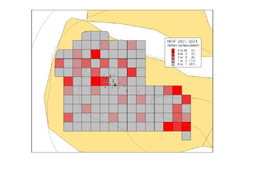
Figure 1. Pottery Surface Density at S034.
In 2000, artifacts were collected from the surface of the site. A Total Station was used to stake out 120 10 x 10 meter grid squares covering much of the aforementioned interfluve. A "grab" sample of diagnostic artifacts was collected from each square, and at each square's center all artifacts were collected in a circle 126 cms. in diameter (c. 5 m2). Surface densities can be mapped using data from these latter "vacuum" samples (Figures 1-3). Surface collections appeared to indicate the existence of two concentrations of material, one near the west end of the interfluve and one further up the slope to the east.
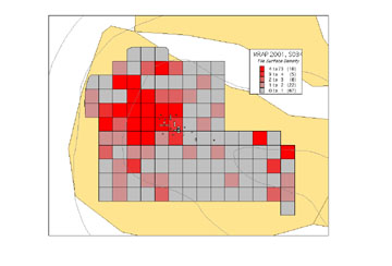
Figure 2. Tile Surface Density at S034.
The eastern concentration was interpreted in 2000 by Lorenc Bejko as remains of a cemetery, and the western as perhaps those of a small house. Unfortunately, the eastern artifact concentration was heavily disturbed by installation and then removal of a gas well at some point in the recent past, and no excavations were undertaken there. Artifacts were most dense in the western concentration and it was targeted for geophysical investigations (electroresistivity and geomagnetometry). Investigations conducted in early June of 2001 by the Department of Geophysics of the Albanian Geological Service revealed buried anomalies in the vicinity of site "center," and these were interpreted as buried walls (Figure 4). (However, given the results of excavation, which did not uncover walls in the areas of highest field strength, it seems likely that the anomalous measurements were caused by pockets of ferrous sand and iron stones that rest just above bedrock.)
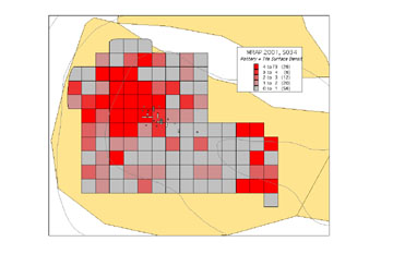
Figure 3. Pottery and Tile Surface Density at S034.
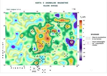
Figure 4. Magnetometry Survey of S034 and Map of Excavated Trenches
In light of the evidence from surface collection and geophysical survey, test excavations were conducted in areas just east of, and up slope from, the highest ceramic concentrations and where buried anomalies were thought to be present. Test trenches were not positioned directly in the midst of the highest ceramic surface densities, as it seemed likely that many fragments of tile and pottery had been displaced downhill onto the steeper western slopes of the interfluve, owing to agricultural activities at the site, primarily plowing, followed by erosion (see Figure 5, water-flow vectors marked on a one-meter contour map of the site). According to our workmen and the landowner, the site underwent two distinct episodes of mechanized plowing in the mid 1960s, one with a deep plow that penetrated as deep as 60 cms., followed by another more shallow. In addition, our informants called the site "Shkoze e Zeze," remembering that a forest of black-barked hornbeam had been cut down prior to deep plowing.
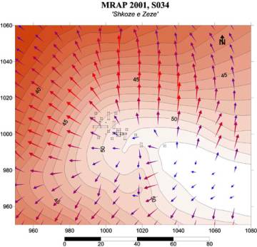
Figure 5. Water Flow Vectors at S034.
On the first day of excavation (24/06/01) two 1 x 4 meter trenches (04T and 05T), separated by a narrow baulk, and three 1 x 1 meter sondages (01T, 02T, and 03T) were opened (Figure 6). The surface of each unit was cleared of vegetation and artifacts on the surface were systematically collected. In general, vegetational cover was relatively light and consisted of grass, thistles, and the occasional small bush. As a result, root disturbance was minimal in all units, as was bioturbation generally. In all units the modern ground surface was labeled "Collection Unit (CU) 01" (i.e. Level 01), a plan of the trench was drawn in most cases, and the surface was photographed in black-and-white and digital color.
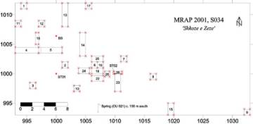
Figure 6. Trench Plan. S034.
A total of 26 trenches were excavated between 24/06/01 and 21/07/01, covering an area of 44 square meters roughly equivalent to grid squares 111, 112, 211, 221, 241, 311, 411, and 412 of the surface collection. In all trenches (01T-020T), CU 02 was a "yellowish-brown" clay-silt loam plow zone, which, when picked or troweled, came up in large chunks. All earth was screened through 1/4-inch mesh and pieces of ceramic larger than a thumbnail were kept and bagged by level. In all trenches, natural stratigraphy was followed, and natural strata were not sub-divided into arbitrary levels. The plow zone was in some cases quite thin (5-10 cms. thick), but was in most cases 20-30 cms. thick. Many artifacts were found in this level, though often they were oriented vertically, and may have slipped down widespread large cracks in the earth or have been turned by the plow.
In many trenches the plowed A-horizon sat directly on top of a chalky, clay C-horizon (CU 03), which was completely devoid of artifacts. In 03T, a sounding 26 cms. deep was dug into the C-horizon, to a total depth of 57 cms. below the surface: no additional artifacts were found.
In several trenches plow scars had been cut into the first 5-10 cms. of CU 03. Scars are especially visible in 13T and 14T, 1 x 4 meter trenches that run north-south, perpendicular to the direction of plowing. It is likely that these plow scars were produced by the deep plowing undertaken in the 1960s. However, in some trenches it is clear that deep plowing did not reach CU 03 and that relatively undisturbed strata (CU 04-11) are present.
CU 05 is found in some trenches between CU 02 and CU 03. It is higher in clay content than CU 02 and overlies CU 03. This stratum appears to be an undisturbed B-horizon that was not deep plowed. It is often quite thin (<5 cms.) and represents a "mixed" zone, which in some cases grades into CU 03. There are in some trenches patches of fine sand between CU 05 and CU 03, and lenses of ferrous and calcareous precipitates may also mark this interface. Artifact density in CU 05 is typically low.
CU 06 was found only in 09T, the trench situated farthest to the east. It is a thin layer of gray clay between CU 05 and CU 03. It is likely that this stratum is related to the underlying stereo (CU 03), in that it was from this fine clay (and from CU 03) that the overlying soils were formed. (There was also a thin layer of darker clay in this trench, between CU 06 and CU 03, which was tentatively labeled CU 04, discussed below. However, upon further investigation it became clear that this level, which was void of artifacts, should properly be considered a member of CU 03. No artifacts were found in CU 06.)
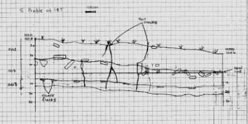
Figure 7. Sectional Drawing of South Profile of 18T.
CU 04 was first identified in 06T. It is an organic-rich layer of dark clay, with many flecks and chunks of charcoal. Artifact densities were high in this CU: for example, a nearly complete brick sat close to the interface of CU 04 and CU 03. Because CU 04 seemed to be unique, and was perhaps an undisturbed cultural level, trenches 18-20 and 22-26 were opened to the north, east, and south of 06T (Figure 6). CU 04 was encountered in each of these new trenches, especially, in the case of 18-22 and 24, at their eastern ends, and in the case of 23, at its northern end. The level was most thick and rich in the eastern and southern portions of 18T, where it was capped by a layer of large tile chunks (see profile and photo, Figures 7-8). As in 06T, fragments of brick were again found in the lower reaches of the level. In addition, the evidence for burning was especially strong in 18T, where there were many fairly large chunks of charcoal and the soil was especially dark. It is hoped that a radiocarbon date for this material from CU 04 can be obtained, thereby dating the site's occupation independent from ceramic analysis.
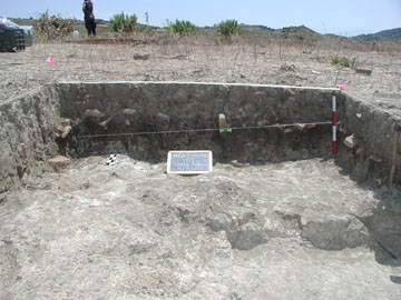
Figure 8. South Profile of 18T. Site 034
Two trenches in particular deserve more detailed description. Approximately 100 meters to the south of S034, down an increasingly steep slope and surrounded by cattails, is located a small spring. The spring has apparently been in existence for some time, as a number of chipped stone tools were found nearby, most of which appear to be Paleolithic in age. In addition, Hellenistic material was excavated from the spring's gully wall, including parts of an hydria and a large amphora. This small excavation was designated 21T, and the presence of the spring helps to explain the attraction of S034 as a place of settlement: reliable and easy access to fresh water must have raised the property's value considerably.
Between 16/07/01 and 21/07/01, several trenches (22T-26T) were opened in the vicinity of 18T (see Figure 6) in order more accurately to define the extent of CU 04, which was eventually identified in the eastern end of 24T, the northeastern half of 22T, within most of 25T, and to some degree in 23T, especially in the northern third of the trench. As in 18T, CU 04 was in these trenches high in organic content, especially charcoal, and artifacts: square iron nails were found in most, and an iron spear point was recovered from 24T. Ceramic artifacts were dense in these trenches, as well, including a thick layer of tiles above CU 04, as was found in 18T (see Figures 7-8), and a large number of sherds from cooking pots. In addition, in 23T were found three tile wasters and a number of apparently formed, but unfired tiles, perhaps indicating on-site tile production (cf. Pentinnen 2001: 15-18). At the north end of 23T, three limestone building stones were uncovered, sitting directly on top of CU 03. Between the stones and immediately to their south was a relatively thick layer (several centimeters in some places) of charcoal and burned soil. This layer was designated CU 07.
CU 07 was thought to perhaps mark a hearth, or destruction level. There also seemed to be chunks of bitumen mixed in with the charcoal and, alternatively, CU 07 may have been produced by some kind of industrial process. After a soil micromorphological sample was taken by M. Timpson, the level was removed, and was found to overlie CU 03. Because of the unusual nature of CU 07, a small trench (25 x 150 cms.), 26T, was dug to the north of 23T on the last day of fieldwork (Figure 9). Excavation revealed that CU 07 extended to the north and east and that additional stones in 26T were joined to those from 23T, apparently once forming a two-faced foundation wall (CU 10). CU 07 was strongly associated with the wall and may in fact be, therefore, the remains of a burned wood or wattle and daub superstructure. In the northwest corner of the trench was found a very thick layer of tile fragments (labeled CU 09), some quite large. Given the paucity of tile fragments from 26T CU 02, it is likely that CU 09 had not been disturbed by deep plowing, perhaps having been shielded by the aforementioned wall. The tiles from CU 09 were removed to reveal CU 04, identical to that found in other trenches, and overlying CU 003.
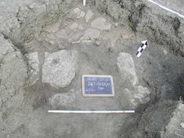
Figure 9. Trench 26, CU 07, 09, 10
At present, we may explain the presence of CU 04 at S034 in four different ways. First of all, it may be that CU 04 is not an ancient deposit, but rather a modern anomaly, perhaps relating to the grubbing out of tree stumps in the 1960s and the subsequent re-working of disturbed soils. However, stratigraphic observations, especially from 26T, would seem to argue against this interpretation; not only is CU 04 found in several trenches (those surrounding 18T), always sandwiched between tiles and bricks, but it is not found elsewhere on the site. It seems likely that the level, localized as it is, is ancient. It appears to have been protected from the plow.
Second of all, it may be that CU 04 and CU 07, are somehow related to tile production, charcoal in both levels originating from the firing hole of a yet undiscovered kiln, as at Pyrgouthi (Pentinnen 2001: 15-18). At this point, besides a few wasters and the formed, though unfired tiles, mentioned above, there is no additional evidence for tile manufacture, and so this scenario remains hypothetical.
Third, it may be that CU 04 represents the remains of a farm yard, that was once situated adjacent to, but not within, a house. Bricks may have served as post supports for a shed, with a tile roof, attached to the main building (as at the Dema house; Jones, Sackett, and Graham 1962: 76, fig. 1). The pot sherds found in this level may have been tossed out of a back door, as may have been the charcoal. Vegetable and fecal waste may have been trampled into the clay by farm animals. Alternatively, the charcoal and tile may represent the burning of the house, and its subsequent collapse onto and over part of the farmyard.
A final possibility may be that CU 04 is a preserved portion of a structure's dirt floor. There are arguments for and against this interpretation, though the remains from 26T seem to strengthen this explanation considerably. It seems entirely possible that a small Hellenistic farmhouse might have had a dirt floor (see Pentinnen 2001: 33); however, the builders of most excavated Greek domestic structures appear to have removed excess soil, allowing bedrock, in the absence of mosaic, pebble, or plaster surfaces, to serve as a natural floor (as at the Dema house; Jones, Sackett, and Graham 1962: 77). CU 04 is very high in organic content and must have been infused with large amounts of vegetable waste and/or fecal matter. This would seem to argue against its having been an interior floor. But, the overlying layer of tiles and the evidence for burning might have resulted if a fire in a building with a dirt floor was followed by the collapse of a tile roof.
At present, there would appear to be no good way to choose between these various alternatives, and, of course, it is equally possible that two or more acting together produced CU 04. However, it may be that the results of scientific analyses may favor one particular explanation over others. First, radiocarbon dating may help to determine if the deposit is ancient. Second, micro-stratigraphical analyses should help to determine if CU 04 is undisturbed and whether or not it is a floor. Finally, soil chemical tests should indicate to what degree CU 04 has been infused with human and animal waste, relative to surrounding soils.
What then are we to make of S034? It certainly appears that the structure which once stood at Shkoze e Zeze was not very large, nor was it well-appointed; the inhabitants may have indeed been poor farmers. However, this assumption should be treated with some caution. The site has been very disturbed, and much of the original building material may have disappeared, either eroded downslope, or, scavenged for whole tiles, bricks, or building stones. On the other hand, S034 is unlike all other excavated Classical/Hellenistic domestic structures in that substantial architectural remains are absent. It may, in fact, be the case that the structure had no more than stone foundations, and this would not be surprising given the paucity of suitable material in the vicinity of Apollonia. The structure may have been almost entirely constructed of sun-dried mud-brick or wattle and daub that decayed following abandonment. Small flecks and chunks of clay found in the plowzone and in CU 04 may represent the remains of such a superstructure (see Pentinnen 2001: 34, 36), as might CU 07.
Test excavations at S034 have supported the proposition that small ancient sites, defined in the course of surface survey throughout the Mediterranean, really are the remains of small rural farms. They are not simply the better preserved remnants of a once continuous ceramic background scatter. Nor have they resulted from purely modern processes, such as the mining of ancient deposits for fertile soil to be spread on fields elsewhere. S034 and sites like it represent the movement of individuals, homesteaders or tenant farmers, into Apollonia's vacant hinterland during the Hellenistic period, a process probably driven by changes in regional political organization and economy. Analysis of the finds from the site also supports this interpretation.
By Michael L. Galaty and Skënder Muçaj
Site 038 was also found by H team in 2000 during the course of surveying the north side of the Gjanicë river valley between the villages of Plyk and Kraps. It sits near the hamlet of Mbyet atop the ridge that separates the valley of the Gjanicë from the flood plain of the Seman. The town of Portëz lies immediately to the north. The site was originally discovered by S. Muçaj and a small collection of pot sherds made, which were later published by N. Ceka (1990). Based on his reading of this material, Ceka argued that "Kraps" was a Late Bronze Age settlement, but the results of our test excavations have lengthened the site's span of occupation to include earlier periods of the Bronze Age, and perhaps the Late Neolithic as well. A handful of chipped stone tools may point to still earlier, probably Paleolithic, use of the site.
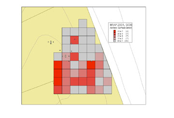
Figure 10. Surface density map of S038, with excavated trenches
Following survey of the site in 2000, artifacts were systematically collected under the direction of L. Bejko. 49 10 by 10 meter grid squares were "grabbed" for diagnostics and all artifacts were "vacuumed" from a 5m2 circle at the center of each square (Figure 10). However, according to Bejko, because surface densities were relatively low, in practice nearly all ceramic material found on the surface of the site was retained, despite the fact that the vast majority was not diagnostic. A particularly striking find, retrieved from the surface of the site, was a bronze knife blade, reminiscent of "Mycenaean" types. On subsequent revisits to the site, a piece of a bronze fibula and a chert arrow point were collected.
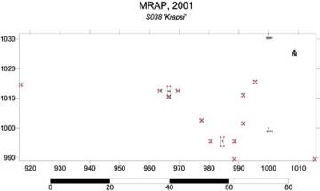
Figure 11. Trench Plan at Site 038.
Bejko also estimated the site's size at approximately 0.5 hectare. The site may, however, have been as large as one hectare, as there are concentrations of artifacts along the ridge to the southeast that were not included in the surface collection. As a result, in 2001 some test excavation units lie outside the bounds of the area that was surface collected in 2000 (see Figure 10).
Test excavations at S038 were carried out between 05/07/01 and 12/07/01, during which time a total of 14 trenches covering 18 square meters were opened (see Figures 10-12). Trenches 01-05 and 07-09 were excavated in grid squares 122, 211, 221, 222, and 312, in order to test within or just above areas of highest artifact surface density. Trench 11 was placed at the far western edge of the site, outside the bounds of the surface collection, near a concentration of pottery that had eroded onto a lower terrace. Trenches 06, 10, and 12-14 were situated farther up the slope to the north and west, outside the bounds of the surface collection, on somewhat more level ground. Where possible, trenches were excavated following natural stratigraphy, and in several trenches (02-06), natural strata were divided into 10 cm. arbitrary levels. All soil was passed through 1/4 inch mesh, and all pot sherds were kept, regardless of size.
In all trenches, artifact densities were rather low. It appears likely that S034 has been seriously damaged through time by erosion, such that older, redder soils, those associated with the Bronze Age and earlier periods, now rest near the bottom of the hill to the south, carried there by gully erosion which had been exacerbated by recent plowing (Figure 13). Surface levels (CU 01) were photographed and, if necessary, drawn, and artifacts were collected. CU 02, which held very few artifacts (although a denticulated sickle element, possessing sickle gloss, was recovered from 05T CU 02), designates the silty clay loam A-horizon, a plow zone present in the first 10-30+ cms. of every trench. In nearly all trenches, CU 02 was positioned above sterile soil, a yellowish-brown loam derived, depending on the position of the excavation unit, from either underlying marl or sandstone bedrock.
In Trench 10, a dark brown, silt-loam stratum that was unlike CU 02 was identified approximately 52 cms. below the surface, concentrated in the north end of the unit, running to a depth of approximately 85 cms. Two pieces of decorated prehistoric pottery were recovered, suggesting that perhaps this new level (CU 03) was not disturbed by plowing. In order to trace the extent of CU 03, a three-meter trench (12T) was extended to the north of 10T. CU 03 was again identified, especially in the southern third of 12T, and a 1 x 1 meter sondage was excavated in this portion of the trench.
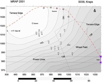
Figure 12. Contour Map of Site 038.
As excavation progressed, it became apparent that CU 03 represented the poorly preserved remains of an occupation or perhaps midden horizon. The level was rich in organic material and artifacts, including charcoal, pot sherds, some small and burned, and quite a few broken and burned bone fragments (some perhaps rabbit, others splinters of long bone from a larger mammal), and it seemed to emanate from a pit feature, perhaps a hearth, located in the NW corner of the sondage. The upper portions of this feature had apparently been removed by a plow and the contents spread downslope, filling plow furrows. As a result, the fill in the plow furrows and from the feature was removed separately from CU 03, as CU 04. As with CU 03, CU 04 was very rich in artifacts, especially pottery, and there were again a number of long bone fragments.
On the last day of fieldwork, the feature was removed whole and sectioned. One quarter will be subjected to flotation for the recovery of charcoal and burned botanical material. The humic content of the soil from another quarter will be extracted for AMS dating. And one half of the feature will be retained for future analyses. If the feature can be dated, we can, by association, date the ceramic material found within it, and provide an absolute date for the site's occupation. Beneath the feature, CU 04 dives down to a depth of at least 42 cms. beneath the surface, at which point excavation ceased. In addition, CU 03/04 appears to level off and continue to the north. Continued excavation of the northern two-thirds of 12T would have, it seems, eventually revealed more of CU 03/04. For this reason, a return to S038 in the future, for the purpose of additional excavation, might prove worthwhile.
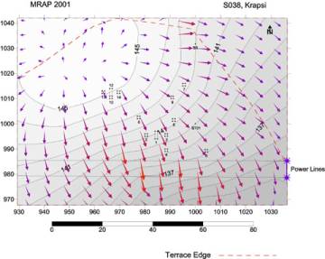
Figure 13. Water Vector Map of Site 038.
By Charles Watkinson
Over a period of six days intensive survey was carried out in order to complete coverage of the uplands between Levan and Apollonia and also to place S034 in context. The terrain covered consisted of a series of steep hills sloping down to the Perroi Levanit from the Radostina-Jaroi ridge road. Mali Dardhës, at the southernmost end of this ridge, forms the highest point of this range of five hills at 140.3 m.
The area surveyed was bounded by tracts walked by C Team in 1999 and A Team in 1998. To the north D Team tracts walked in 1999 included S032, a concentration of Hellenistic material more intensively collected in 2000.
The slopes of the hills covered have all been terraced with bulldozers. Many of these terraces are now heavily overgrown and only used for grazing. The terrace soils have beem highly disturbed, making it unsurprising that few artifacts were found in this context. The hilltops are also heavily eroded, with indications of military workings (bunkers, roads) everywhere. Soils are light colored and in many areas bedrock is exposed.
Despite the poor preservation of original contexts, some interesting material was collected and patterning observed. Density maps indicate that Hellenistic material was widely distributed on the terraces immediately below most of the hilltops which protrude from the ridge road, albeit in small quantities. On the Lower Terraces just above the Perroi Levanit a small but even scatter of lithic material was collected including some characteristic Paleolithic material, mirroring a pattern noted by C Team on the bluffs opposite.
Most exciting was the discovery of a concentrated scatter of diagnostic Hellenistic tiles and cooking ware on the saddle of one of the highest hills, with good views to both Apollonia and S034. A millstone fragment and some lithic artifacts were also observed in a 0.7 ha area which has been designated S040.
On the final day, survey on the hill adjacent to S032 indicated that this site may be larger than previously supposed. While Hellenistic material was plentiful, an Ottoman component was also discovered which may possibly be linked to material collected on the other side of the ridge road, facing towards Shtyllas, by A team in 1998. The 19th Century French traveler Heuzey mentions the konak of a family of Albanian beys in this valley, and these finds may perhaps be associated with that estate (L.Heuzey and H. Daumet, Mission archéologique de Macedoine [Paris, 1876]).
Lastly, the ridge road itself must not be forgotten as an important structuring component in this area and a number of isolated finds during survey may well be the result of breakages from passing traffic. In modern times it has cut through a site (S011) more intensively examined in 1999, and a number of finds from tracts opposite this site contain material washed down from the road; some all the way to the base of gullies feeding Perroi Levanit.
By Michael J. Timpson
Because of conflicting commitments Sergei Yazvenko was unable to join us in the field in summer 2001. Analysis of pollen recovered from cores taken in the lagoon of Nartë near Vlorë is, however, advancing in the laboratory. Preservation of pollen is good and it may be possible to use cores already extracted to reconstruct a relatively complete vegetational history for the area from the Neolithic period to the present. C-14 dating of shells has yielded a date of 7090+/-60 14-C yrs. B.P. at 10.5 m. (cal. B.C. [6016] (5947, 5896, 5893) 5852 for 1 sigma interval). C-14 dating of plant remains at 10.5 m. gave 6780 +/- 60 BP, or cal. B.C. 5680 (5625, 5612, 5602) 5584 for 1 sigma. With different coring apparatus in the future it may well be possible to reach still older deposits.
Timpson's own research focused on three separate projects: geological studies at S034; geological studies at S038; and investigations of the Kraps and Peshtan areas. General conclusions are outlined as follows. A more detailed report will be circulated later in the year.
Site 034. Soils at the site derive from a mudstone and include clays derived from marine sediments. In 2001 these soils were deeply cracked owing to a particularly low moisture content, the result of low rainfall in the area in the spring. A charcoal sample from near the nose of the bluff may mark the time when the site was cleared of hornbeam forest. If so (and this will be determined by radiocarbon dating), there has been some 70 cms. of erosion here since the mid-1960s. The thin soils on the site contrast dramatically with the thick terra rossa soils that have been formed on sandstone bedrock on the ridge to the south of the site and that largely remain still in situ. Paleolithic surface finds have been collected there.
From the excavation itself samples for micromorphological examination were taken from 18T at the transition between level 002 and level 004, as well as purely within levels 002 and 004. Similar samples were also taken from the layer of charcoal and bitumen in 23T. In addition, charcoal samples for radiocarbon dating were collected in the south wall of 18T-004.
Site 038. Soils were very eroded. It is likely that once there was present at the site a mantle of red soil 30-50 cms. thick, most of which now lies at the bottom of the slope, at the base of the interfluve on which the site is located. Most of the artifacts that we recovered in excavations remained as the result of the process of erosional lag, according to which larger fragments of pottery and more durable artifacts have yet to be washed downslope or to be entirely decomposed through erosion.
Gjanice valley near kraps. Our colleague Skënder Sala of the Albanian Institute of Geology suggests that the oldest riverine terraces in the Gjanice Valley near Kraps are no older than the end of the last glaciation, ca. 10,000 B.C. Our own examination of soils on the lower side slopes of one of the lower terraces seems to support this conclusion but is also difficult to reconcile with the fact that MRAP survey teams have found Lower and Middle Paleolithic artifacts on top of these terraces. Moreover, these have not be found in contexts or in a state of preservation that suggests that they have been transported long distances. The best way to unravel this conundrum next year would be to dig a trench with a mechanical excavator in the top of a terrace so that its stratigraphy can be studied in greater detail.
Peshtan Valley. Erosion is severe in the valley, particularly on its western side, that is largely composed of marl. In the middle of the valley are scattered pockets of red soils. The noses of knolls on the eastern side of the valley appear to have been partly protected from erosion by gravelly deposits laid down by a Pliocene river channel. The fact that not much cultural material was found on these in the course of archaeological survey does not seem to be owing to geological causes. Prospection for deposits of chert did not result in the discovery of material any larger in size than the cobbles found elsewhere in the Apollonia region.
By Sharon R. Stocker
Analysis of Artifacts from Site 034
Most artifacts from Site 034, both from excavations and surface collections, were studied in the museum by Skënder Muçaj and Sharon Stocker, with assistance from Marion Parker. Selected finds were drawn and photographed. Although heaviest surface densities were in Quadrant 4, densest subsurface deposits were in the southwestern corner of Quadrant 1. In parts of the site, corresponding to Quadrants 1, 2, and 4 of the grid established for surface collection in 2000, finds appear almost exclusively to be of late 3rd-early 2nd B.C. date. Several lithics are likely to be prehistoric; one is certainly Middle Paleolithic.
Surface finds reflect subsurface finds both in their date and nature: in both assemblages tiles are dominant and there are a few amphorae. Most tiles are plain, but a few are black-glazed (Figure 14).
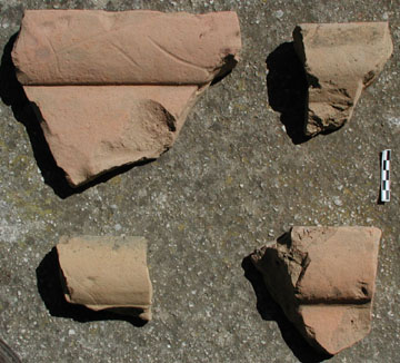
Figure 14. Typical Pan Tiles from Site 034
All tiles were counted and weighed. Cover tiles are likely to be underestimated in these statistics because of the difficulty in identifying them from small fragments (Figure 15). Four fragments may derive from some sort of decorative architectural terracotta. There are fragments of two special purpose tiles, one perforated for admitting light, another for use as a chimney. Most of the tiles, both pan and cover tiles, share a similar fabric that may be described as follows:
COLOR. 5YR 7/6 to 7.5YR 7/6
TEXTURE. Fine and gritty; tempered with reddish brown sand, for the most part smaller than 1 mm., rounded but still angular. Occasionally there can be observed a shiny translucent fleck smaller than 0.1 mm. There are also a few light gray grains of sand that, under a hand lens appear to be quartz. Some voids, a maximum of one centimeter in size, can be seen in fractures.
FIRING. Surface and profile are fairly uniform in color and have no reduced areas, even at the thick edges of pan tiles. The fabric may be slightly pinker in the fracture than at the surface (5YR 7/4).
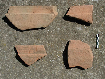
Figure 15. Typical Cover Tiles from Site 034
Sherds from very few vessels were found, but all components that might be expected in a household assemblage are represented: pieces of coarse pithoi, probably in two different fabrics; a few fragments of transport amphorae; cooking wares. A skyphos appears to be represented among fine black-glazed sherds. Hellenistic metal small finds included a number of iron nails and what appears to be a bronze arrowhead. A piece of a vesicular volcanic stone, almost certainly a fragment of a millstone, is likely also to be of that date.
In Trench 26 and its vicinity, finds were less dense in surface levels. Artifacts from subsurface levels, on the other hand, were better preserved and included among them fragments of unfired Hellenistic tile, both pan and cover tiles (Figure 16). The presence of such finds strongly suggests that tiles were being produced at this site. It is indisputable that these tiles are unfired. When fragments are soaked in water they revert to clay, a phenomenon that would be impossible had they been fired, since in that case the fundamental mineralogical structure of the clay would have been irreversibly altered.
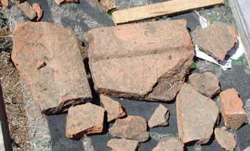
Figure 16. Fragments of Unbaked Tiles from S034-26T-009.
In the far eastern end of Quadrant 2 of the grid established for surface collection in 2000 (specifically from grid squares in the 270s, 280s, and 290s, finds were different. There was more black-glazed pottery, and in general a higher density of pottery to tile (Figure 17). Almost all pottery was contemporary with that in Quadrant 4, but a single rim fragment came from a Classical black-glazed krater, and a few fragments were of Ottoman-modern date.
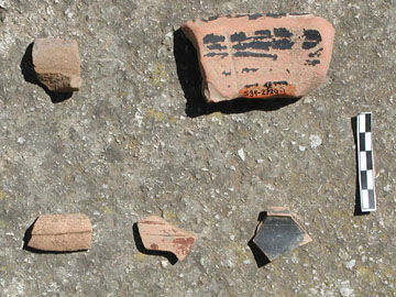
Figure 17. Selection of Fine Wares from the Eastern Part of Site 034.
Analysis of Artifacts from Site 038
A selection of diagnostic finds from this site had already been published in 1990 by Neritan Ceka "Periudha paraqytetare në treven Bylise," Iliria 1990, 2: pp. 137-160; see pp. 142-43 and pl. 4, "Kraps"). In 2000 our own project collected a large number of sherds (see Mallakastra Regional Archaeological Project: Third Season Preliminary Report, July 30, 2000). The ceramics included plain ware, reddish brown in color, with many inclusions and with thick walls. A few black sherds with a polished surface, together with some small circular handles suggested the existence of a middle Bronze Age component at the site. However, the main component of the site seemed to date to the late Bronze Age. Bronze Age material comes from 23 tracts in this area and all of it is plain ware.
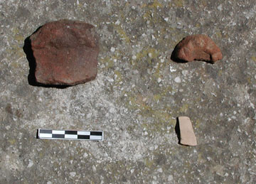
Figure 18. Prehistoric Pottery from Site 034. Mycenaean Sherd at Lower Right.
Most pottery recovered from excavation in 2001 was scrappy and diagnostic. The majority was examined by Muzafer Korkuti, on whose comments the following discussion draws. Many fragments were coarse with a burnished surface. On the other hand, excavation produced an incised sherd probably of Neolithic date and contemporary with finds from the site of Cakran, to the southeast in the Vjosa valley (Korkuti and Andrea, "Stacioni i neolitit të mesëm në Cakran të Fierit," Iliria 3 (1974) figure xix), as well as additional Bronze Age pottery (cf. Prendi, "Epoka e bronzit në Shqipëri," Iliria 7-8 (1977-78) figure 3, 1-3). Korkuti draws our attention also to Neolithic finds from Lalar, also in the Fier district. As elsewhere in the southern Balkans the Neolithic period may have been a time of considerable expansion in the establishment of small open residential sites (see J.F. Cherry, J.L. Davis, A. Demitrack, E. Mantzourani, T. Strasser, and L. Talalay, "Archaeological Survey in an Artifact-Rich Landscape: A Middle Neolithic Example from Nemea, Greece," American Journal of Archaeology 92 (1988) 159-176). A few shapes appear to be of LBA date, , including one sherd that appears to be Mycenaean in shape and fabric (Figure 18). Several lithics also appear to be of Bronze Age date. A few Hellenistic black-glaze sherds point to post-Bronze Age use of the site, as does the pin from a bronze fibula found nearby.
Other Studies in the Museum
Analysis of MRAP finds occurred over a period of nearly three weeks from July 5-23. Although work concentrated on the processing of finds from excavations at Sites 034 and 038, it was also possible to make some headway in the processing of unstudied finds from 2000. In addition, and subsequent to Runnel's examination of lithics, a complete inventory of all small finds was conducted by Mëhilli and Parker. The very few problems that were found in labeling and in our databases as a result of data entry mistakes were corrected.
A full report on the results of lithic studies in 2001 is in preparation by Curtis N. Runnels and Muzafer Korkuti. Runnels and Korkuti, assisted by Priscilla Murray and Arta Mëhilli, in ten days completed an initial examination of virtually all chipped stone artifacts (more than 2000) collected by the project in 1998-2000. The vast majority of these are of Paleolithic and Mesolithic date: Lower, Middle, and Late Paleolithic phases are represented. Data were recorded by Murray and subsequently entered in the MRAP Small Finds database by Mëhilli.
[1] Participants in fieldwork in 2001 included Jack Davis (director of the foreign team), Philip Davis, Christopher Dore, Matthew Fenwick, Michael Galaty (co-director), Besa Gjeçovi, Evi Goroyianni, Sami Hasa, Garrett Holden, Muzafer Korkuti (director of the Albanian team), Olsi Lafe, Arta Mëhilli, Skënder Muçaj (co-director), Priscilla Murray, James Newhard, Marion Parker, Enina Poci, Curtis Runnels, Sharon Stocker (co-director), Michael Timpson, Sabina Veseli, John Wallrodt, Charles Watkinson, Ben Witt, and Ilir Zaloshnya.