Second Season
22/6/99-24/7/99
by
Muzafer Korkuti
Jack L. Davis
with contributions by
Lorenc Bejko
Michael L. Galaty
Skë nder Muç aj
Sharon R. Stocker
Charles Watkinson
Staff of the Project
The Mallakastra Regional Archaeological Project is a fully integrated cooperative program of regional archaeological research, sponsored by the Institute of Archaeology (Tirana) and the Department of Classics of the University of Cincinnati (USA).[1] MRAP is jointly directed by Professor Professor Jack L. Davis and Professor Muzafer Korkuti and is co-directed by Lorenc Bejko, Professor Michael Galaty, Skë nder Muç aj, and Sharon Stocker. Staff members in the second season of the project were drawn from a number of universities, research institutions, and consulting firms in Albania and abroad.[2] Professional archaeologists participating in the project, their institutional affiliations, and responsibilities were as follows:
Muzafer Korkuti Institute of Archaeology (Tirana) Director
Jack L. Davis University of Cincinnati Director
Maria Grazia Amore Institute of Archaeology (Tirana) Museum Staff
Lorenc Bejko. Institute of Archaeology (Tirana) Team Leader
Bonnie Beverage University of Cincinnati Photographer
Michael L. Galaty Millsaps College Field Director
Wayne Lee Duke University Team Member
Nermin Më rtiri Institute of Archaeology (Tirana) Photographer
Skë nder Muç aj Institute of Archaeology (Tirana) Ceramic Analyst
Sharon R. Stocker University of Cincinnati Museum Director
Michael Timpson Peterson Environmental Consulting Geoarchaeology
John Wallrodt University of Cincinnati Computing
Charles Watkinson Oxbow Books, Oxford Team Leader
Sergei Yazvenko LGL Ltd. Paleobotany
Ilir Zaloshnja Institute of Archaeology (Tirana) Illustrator
Students participating in the project and their responsibilities included:
Blerina Dode University of Tirana Fieldwalker
Ç lirimi Duro University of Tirana Fieldwalker
Jonald Kodheli University of Tirana Fieldwalker
Arta Më hilli University of Tirana Fieldwalker
Enjgë llushe Morina University College London Fieldwalker
Jim Newhard University of Cincinnati Total Station
Libby Percival University of Cincinnati Computing
Eduart Shehu University of Tirana Fieldwalker
Jan Verstraete University of Cincinnati Museum Staff
Aaron Wolpert University of Cincinnati Fieldwalker
Eight nationalities were represented among members of the project in 1999: Albanian (10); American (8); Australian (1); Belgium (1); English (1); Irish (1); Italian (1); Kosovar (1); and Russian (1).
Overview of the Program of Research in 1999
ARCHAEOLOGICAL RESEARCH. General goals of MRAP were outlined in our Field Report for 1998. Methods employed in 1999 were the same as those previously described: intensive survey in conjunction with systematic collection of a sample of artifacts both from tracts (parcela) and sites. The efficacy of these methods seems clear. Not only have we been successful in identifying a large number of concentrations of archaeological sites of many different periods of the past, but careful attention even to small and worn fragments of pottery and lithics is paying dividends. We have been able to locate even the very evanescent remains of Neolihic and Early Iron Age land use (see below). 6200 artifacts were collected by MRAP in the field in 1999 and are now permanently stored in the museum of Apollonia. These collections will provide scholars with a permanent reference collection of shapes and fabrics of ceramics from sites in the area long after, as seems inevitable, many have been destroyed by the expansion of invasive non-traditional agricultural techniques.
With the goals of the project in mind, three survey teams worked in the field daily, in the following areas:
1) Team C in an area southeast of Apollonia between the villages of Shtyllas and Levan;
2) Team D in an area northeast of Apollonia between Havaleas and Fier;
3) A third "Total Station" team began the preparation of a detailed contour map of the nekropolis of ancient Apollonia and to document thoroughly Paleolithic remains discovered in the same area in 1998.
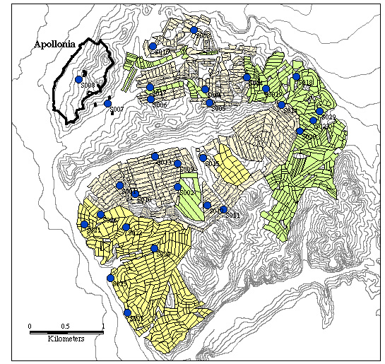
A total area of 6.5 square kilometers was investigated in ca. 21 days of fieldwalking in 749 tracts by teams C and D; in the course of the fieldwalking eleven previously unknown concentrations of artifacts were designated as "sites" and earmarked for further investigation (Figure 1).
Figure 1. Map of Sites and Tracts Defined in 1999.
These included:
Site 018. Team D. Tracts D-095, D-096, D-097, D-098. In a small valley is situated between the first two hills east of Radostina on the road towards Vadhiza. Periods represented: Late Byzantine, Early Ottoman, Ottoman.
Site 019. Team D. Tracts D-064, D-065, D-066, D-067, D-072, D-073, D-074. On a hill slope right of Radostina-Shtyllas road. The site faces the valley southeast of Radostina. Periods represented: Late Roman; Hellenistic; ?Medieval; ?Ottoman.
Site 020. Team D. Tract 200. In a fenced field by the road from Radostina to Mali i Portë s. Periods represented: Hellenistic.
Site 021. Tracts C21-23,25-26 and 31-33. On a ridge immediately east of the main Shtyllas-Levan road, just south of Shtyllas village. Periods represented: Palaeolithic?; Hellenistic-Roman.
Site 022. Tracts C48-50, 74 and 77. On the SW spur of Mt. Shtyllas (188 m.), west of a track leading from Shtyllas Jaroi towards Ç uka e Bukur. Periods represented: Palaeolithic?; Hellenistic-Roman.
Site 023. Tract D190. On slope facing Vadhiza valley. Periods represented: Hellenistic; Roman; ?Ottoman; ?Modern.
Site 024. Primarily associated with Tract B137. In bed and scarps of a small field road near Radostina. Periods represented: Middle and Upper Paleolithic; Mesolithic?
Site 025. Tracts D211 and D378. Shtyllas-Jaroi village. The Ottoman village seems to have been to the east of the main Shtyllas-Levani road, whereas the modern village lies farther west, between the road and the Vjose-Levan-Fier canal. Periods represented: Hellenistic; Ottoman.
Site 026. Tracts C007 and C-008. 400m southeast of Shtyllas village. Periods represented: Hellenistic.
Site 027. Tracts C239 and C240. Immediately east of the main Shtyllas-Levan road, about 500 m. north of Shaban village. Periods represented: Hellenistic-?Roman.
Site 028. Tracts C-095, C-096 and C-099. In the middle of the Shtyllas-Jaroi valley, about one kilometer east of the main Levan-Shtyllas road junction. A low hill surrounded by fields of straw. Periods represented: Hellenistic-Roman.
In addition to the preceding sites, finds were collected from three sites, defined but not thoroughly investigated, in 1998:
Site 003. Tract B-058. Lithic artifacts in bed and scarps of small field road near Radostina Fasko. Red Pleistocene Alfisols, appear to be 0.5-1.0 meter below current surface. Periods represented: Upper Paleolithic, Middle Paleolithic, and Mesolithic.
Site 011. Tract A-104. Concentration of tiles and pottery in scarps of bluff immediately west of agricultural road leading along the skyline at the east side of the Shtyllas valley. Periods represented: Hellenistic; Roman.
Site 012. Tracts A-107 and A-108. Much tile associated with remains of walls near the spine of a macchia-covered ridge (pulli Shtyllasit), on the southern side of the valley of Shtyllas. Periods represented: Hellenistic-Middle Roman.
ENVIRONMENTAL RESEARCH.[3] In addition to more strictly archaeological fieldwork, the program of environmental research sponsored by MRAP was expanded in its scope to include both geomorphological and paleobotanical investigations. Geomorphological research conducted by Michael Timpson built on the foundations established by Eberhard Zangger in 1998. Timpson acquired geological maps of the area from the Oil and Gas Institute in Fier and discussed briefly the geology of the Fier area with geologists attached to that institute. In addition he examined the geology of the territory around Apollonia, Cakran, and the Gjanice River valley near Kraps. This inspectionpermitted an initial assessment of the condition of the soils in each of the areas (which are in all cases rather well preserved). In cooperation with leaders of field teams Timpson also studied the environmental contexts of a number of archaeological sites, particularly those where Paleolithic finds have been located. His more detailed remarks are incorporated, where relevant, in reports on archaeological investigations in specific areas of the Apollonia region (see below).
In 1999 botanical and palynological investigations were initiated by Sergei Yazvenko. Yazvenko's goals in 1999 were multiple: to begin a survey of modern vegetation in the Apollonia area; systematically to collect specimens of modern pollen; and to examine local wetlands in an attempt to identify locations suitable for the preservation of pollen and for the extraction of sediment cores for pollen analysis. In pursuit of these objectives, Yazvenko initially interviewed geologists at the Oil and Gas Institute in Fier and at the Anglo-Albanian Petroleum Company in Fier. Many cores have, it seems, been drilled in the plain between Apollonia and the sea by the Oil and Gas Institute but no information appears to have been recorded concerning Holocene levels. More successful was Yazvenko's survey of wetlands. The southern, particularly the southwestern parts, of the lagoon of Nartë (at the northern side of the bay of Vlorë ) is the most suitable location in the area for the extraction of pollen cores and in the character of its deposits deserves to be compared with Osmanaga Lagoon in Greek Messenia. Less favorable, but still suitable for the preservation of pollen, seemed to be a small coastal lagoon at Kernicë , west of Apollonia. Using makeshift coring apparatus, Yazvenko was able to extract a single core more than four meters in length from water that was approximately two meters deep.[4] Samples of terrestrial plants were collected from strata near the bottom of the core and their dating by AMS will allow sedimentation rates in the lagoon to be estimated. Half of the core was discarded; the remainder was cut into 30-50 cm. segments and taken to Canada by Yazvenko.
Electronic Mapping Project[5]
OBJECTIVES. In 1999, an Electronic Distance Measuring instrument (EDM; a.k.a. "Total Station") was brought into the field for the purposes of mapping the Apollonia nekropolis.[6] The EDM was also used to facilitate the surface collection of the Kryegjata B Paleolithic and Mesolithic site.
Two approaches to mapping the nekropolis were considered in advance of the 1999 field season:
1) Identifying all of the tumuli beforehand and systematically plotting them on an already existing topographical map;
and
2) Producing a new finescale topographical map of the necropolis and subsequently ground-checking features that resembled burial mounds.
Option 1 was discarded as potentially inefficient, though high-end (and expensive) GPS-based technology might have made such an approach feasible. Option 2, while also time-consuming, was thought to be a more objective alternative, avoiding pre-existing biases, especially those attached to the identification of mounds and estimation of their size.
Mapping of Apollonia's nekropolis was necessary and desirable for two primary reasons:
1) The nekropolis is a very significant archaeological monument that currently suffers various threats (e.g., from looting, erosion as a result of army trenching, etc.) and requires conservation and protection. An accurate map is a necessary first step in constructing a management plan and the solicitation of outside funding in support of the implementation of such a plan;
and
2) Plotting accurate locations of tumuli might eventually allow, in conjunction with controlled surface collection of individual mounds, social and temporal structure (e.g., lineage groupings, socioeconomic variation, growth and development through time) to be inferred from the overall organization of the burial monuments themselves.
NEKROPOLEIS. The cartographic methods described above were tested in 1999 in the so-called "Archaic" nekropolis (surveyed in 1998 as Tract B057). This well-preserved, very distinct tumulus field stands apart from the main nekropolis (ca. one kilometer distant), along the road from Kryegjata to Radostina. It is triangular, approximately 350 meters long and 120 meters wide; we blanketed it with 3049 separate topo points (see Figure 2). Subsequently, ground-truthing by Prof. Muzafer Korkuti identified twenty-one definite and two possible tumuli, all of which could be easily identified with previously mapped topographical features. Four mounds have had pillboxes sunk into them and one mound has been completely destroyed, probably by looters. Tract B057 would also serve as an ideal location for more intensive site-surface collection of individual tumuli and associated robbed graves, eventually allowing the origin and evolution of this portion of the nekropolis to be more accurately dated and understood.
Parts of the main nekropolis were also surveyed, from the end of the ridge nearest Apollonia to electric wires running nearly perpendicular to the ridge (at the eastern edge of Tract B001), a distance of ca. 250 meters (see Figure 3). To date, 1861 topo points have been recorded, covering over one quarter of the total area of the main nekropolis. As with Tract B057, the method has allowed us to define mounds and mound-like features; none of these has yet been ground-checked. Next year, survey will continue in the main nekropolis, eventually moving north across a creek and valley-bottom where we will map a tumulus field that is situated behind the defunct army complex in Kryegjata. It is also hoped that Jan Driessen of the University of Leuven will join the project next year to take low altitude kite photographs of the entire cemetery.
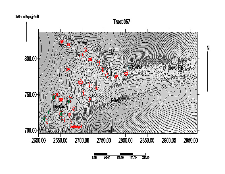
Figure 2. Map of Tract B057, the "Archaic" necropolis, showing area electronically surveyed.
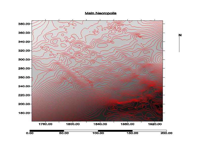
Figure 3. Map of electronically surveyed portions of the main necropolis.
KRYEGJATA B. The Total Station was also employed at the Kryegjata B site (S003) to construct a topographic map and to aid in surface collection of artifacts. The site is situated at the top of a low hill, called Kodra Kutë s and has been bisected by a field road (see Figure 4). According to Dr. Michael Timpson, the field road has cut through a brown A-horizon and through as much as a meter of the B-horizon, a reddish-yellow sandy loam ("Red Bed") that overlies a conglomerate bedrock; the latter is tentatively dated on the basis of its soil development to between 80,000 and 30,000 BP. It is this B-horizon and perhaps the lower portion of the A-horizon that likely contains cultural deposits.
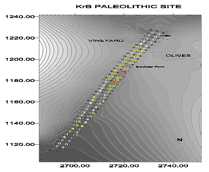
Figure 4. Topographic map of Kryegjata B Paleolithic site, including grid system used for surface artifact collection.
Kryegjata B was discovered in 1998 during regular field-walking. At this time 90 lithic artifacts were collected from the road bed, 79 from surrounding tracts (Tracts B059-060, B066-069); an additional 12 were gathered in a 1999 re-visit. Most were of Middle and Upper Paleolithic date, but there was also a smaller Mesolithic component represented. Later in 1999, a gridded surface collection of the site (78 3 x 3 meter squares; Figure 4) was undertaken principally as a guide to test excavations planned for 2000. 854 lithic artifacts were collected from the road only. Of special importance is a bifacially worked broken leafpoint of the Middle or early Upper Paleolithic recovered in grid square twenty-four (Figure 5); it appears to be the first example of this type discovered in Albania but is of a type found in Greece. Further surface collection of the adjacent fields was not deemed necessary: plowing in these fields has not been sufficiently deep to reach Paleolithic horizons that would appear to be buried 0.5 meters beneath the ground.
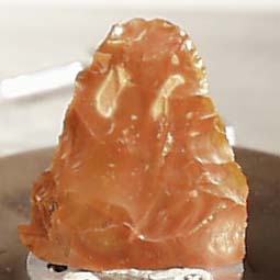
Figure 5. Leafpoint found at Kryegjata B during surface artifact collection.
This surface collection identified a zone (grid squares 10-48) where artifacts were concentrated. These artifacts appear to have been disturbed primarily during road construction, but others have continued to wash into the road bed from its eastern scarp. The best place to excavate seems to be in the olive grove just uphill from the zone of highest artifact concentration.
Finally, a third paleolithic site, as in the case of Kryegjata A (S017) and Kryegjata B, was discovered in the scarp and bed of a small eroded field road.during a routine re-visit to a previously surveyed tract (B137). This site, which we now refer to as Kryegjata C (S024), is located at the boundary between Teams B and C. It is scheduled for surface collection in 2000.
Team C (Shtyllas to Levan)[7]
In 1999 Team C surveyed an area of over 3 km.2, broken up into 380 tracts. Topographically we continued the work of Team A in 1998, moving south, away from the site of Apollonia, towards the town of Levan. In the first week of fieldwork we investigated an area of olive-covered hills and small valleys between Shtyllas and Shtyllas-Jaroi. In the second week of fieldwork we surveyed the horseshoe-shaped valley encircling Shtyllas-Jaroi. In the third week we covered the slopes of Cuka e Lisit, between Shtyllas-Jaroi and Shaban. And in the fourth week we moved up the Shaban valley, investigating areas on both sides.
Before Team C's fieldwork in 1999 very little was known about this network of valleys and hills. Because it is several miles south of the remains of Apollonia, the region has been ignored by both early travellers and archaeologists. The only previous work we know of are the post-WWII excavations of Macsim Gjata at a Roman site in the Shaban valley. We identified the location of his unpublished fieldwork in Tracts 289 and 290.
Although the densities of lithic material are small compared to the Kryegjata valley, the Team C region was clearly visited by Middle Paleolithic groups. Density maps reveal that this material is concentrated on the peaks and east-facing ridges, suggesting that good views over the plain were important for the earliest visitors to this region. Preliminary visits to these areas by soil science and lithics specialists this season also revealed that two of these ridge areas (that topped by Site 021 and the road ascending to Site 022) are sources of chert, with large cobbles eroding from the conglomerate. Since such sources are relatively rare, this is an important discovery, and it is satisfying to see how closely grouped Team C's lithic finds are around these natural resources.
Very small amounts of later Prehistoric material were found this year. Some sherds were found on the saddle of a hill to the southwest of Shtyllas village (in the same area as last year [Tracts A-022 and C-011]). On a single day of fieldwork in the Shtyllas valley (filling in some areas around Sites 011 and 012) we found a fine Neolithic point with marks of "sickle gloss" on the West slopes of Cuka e Bukur (A-121 revisit). However our single most exciting isolated find of the season was three connecting body sherds of an Iron Age vessel (Figure 6), discovered in a drainage channel on the slopes north of Shaban village (Tract 277).
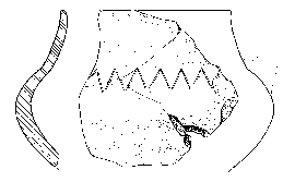
Figure 6. Early Iron Age vessel from Shaban.
Unambiguously identified finds of the Archaic and Classical periods were completely absent from the Team C region.
In marked contrast, a wealth of ceramics from the Hellenistic period was discovered (Figure 7). The density of this material is striking in comparison to Team A's work in the Shtyllas valley in 1998, although it is important to note that the history of that valley has been somewhat rewritten in 1999 by the collection of Hellenistic and Roman Sites 011 and 012 in the macchia covered areas above the central valley pumping station.
At least six new sites with Hellenistic material were designated this year in the Team C region, and a number of significant scatters with less clear boundaries can be observed on a distribution map of the region.
Sites 021, 022, 027 and 028 were more intensively investigated and preliminary analysis has been completed on Sites 021, 022 and Sites 011 and 012 (in the Shtyllas valley; Team A's survey region in 1998).
A functional difference seems to be discernible between Site 021 and Site 022 based on analysis of the ceramics: at Site 021 (low down near the Myzeqe plain) pan and cover tiles of both Hellenistic and Roman periods predominate. The ceramics are mainly coarsewares including amphorae and pithoi. By contrast Site 022 is exclusively Hellenistic with a smaller amount of tile and some finewares. In tract-walking (Tracts 48, 49 and 50) we picked up the highest densities of Hellenistic Black Glaze pottery in the whole Team C region, and this material was also well-represented in our site collection. The scatters are also dramatically different in size: Site 021 had densities covering about 1.2 ha, while Site 022 covered only 0.2 ha. Can we perhaps speak of Site 022 as an ephemeral Hellenistic house, exploiting the panoramic views offered by Mt. Shtyllas? And can we contrast it with a more long-lasting settlement of several buildings down near the plain, inhabited across the Hellenistic/Roman chronological divide by people concerned with the more mundane aspects of life?
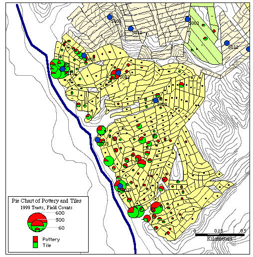
Figure 7. Piechart Map of Pottery and Tile in Area C.
The most striking difference between settlement Sites 011 and 012 is not a functional but a chronological one. Site 011, on top of the ridge, is exclusively Hellenistic (apart from a stray Ottoman tile, perhaps dropped from a passing cart), while Site 012, about 200 m. downslope, is mostly of Middle Roman date (although with a small Hellenistic component to the west of site center). It is also the site of an impressive fragment of a volcanic millstone, an as-yet unidentified coin and some pieces of glass. It is tempting to see Site 012 as a larger successor to the "house on the hill".
The position of Sites 021 and 027, and the general concentration of Hellenistic and Roman material along the modern Shtyllas-Levan road, reveal what may be a major structuring principle of this region in the period of Apollonia's florescence. This is the proximity of the ancient course of the River Vjose which, according to geological investigations carried out by French and Albanian archaeologists in recent years, may have run at this point roughly along the line of the modern Vjose-Levan-Fier canal, parallel to the Shtyllas-Levan main road which formed the western boundary of Team C's region.
In the Team C region (as in all the areas so far surveyed by MRAP) there is a striking absence of Late Antique and Byzantine material.
The villages of Shtyllas-Jaroi and Shaban clearly have Ottoman roots. Ceramics and tiles of this period were found around the edges of both settlements; not, however, in exactly the locations of modern building. In Shtyllas-Jaroi, for example, the densest scatter of material is on the flanks and ridges of Cuka e Lisit (Tracts 187-191, 210-212, 218), much higher up than the existing village which sits on the valley floor and next to the canal. Similarly the Ottoman material from Shaban comes mainly from the middle slopes of the valley (on both the North and South sides), rather than from the modern village next to Perroi Levanit. (Tracts 277-278, 286, 289, 291, 295, 303-307, 310, 314, 317). Although Jaroi is already known to be an ancient village and Shaban is by local tradition the site of an Ottoman flour mill, our work is revealing new information about the location and extent of these settlements in the Ottoman period.
Change has continued in the Team C region into the 20th C. The scars of military excavation have wiped the summits of many of the hills almost clean of finds. The terracing of the Shtyllas-Jaroi valley, and the large units of cattle 'stalla' and chicken houses around both Shtyllas-Jaroi and Shaban are the examples of Communist central agricultural planning. The main legacies now of these grand projects are ruined buildings and extensive erosion. Today's pattern of modest subsistence agriculture based on mixed crops in relatively small fields or garden plots seems a more practical approach to this environmentally diverse landscape.
Team D (Havaleas to Fier)[8]
Team D in 1999 surveyed 370 tracts, covering an area of about 3.5 square (an average size of 0.95 ha per tract). As is mentioned in our final report for 1998, numerous gaps were left in 1998 in the area examined by Team B because many parcels of land were planted with wheat and could thus not be surveyed. Consequently, one of the first goals of Team D this year was to fill in these gaps in so far as that was possible, taking advantage of the fact that fieldwork in 1999 took place in late June-July, a period in which many of the fields passed over in 1998 had been harvested. In addition, Team D surveyed an area southeast of Radostina towards Vadhiza and Vadhiza-Radostima, before moving into the perroi i Levanit valley. This is a hilly area where a number of low ridges are connected by rolling valleys. At the same time this area is very close to the modern city of Fier and dominates its plain. Contemporary infrastructure and topography permits three major units to be defined: a southeastern Radostina unit, the Vadhiza valley, and the perroi i Levanit valley.
Availability of water is a constant problem for local farmers everywhere in the area surveyed by Team: deep wells and artificial lakes are the sole sources. With the collapse of the Communist collective farm economy most of the drainage and watering channel systems and other infrastructure has been destroyed or has deteriorated because of lack of maintenance; this is reflected in the productivity of individual family farms. Fields are arranged and cultivated, according to an individual's economic capabilities and interests. Frequently one can see large areas of overgrown long grass and maquis between cultivated or harvested fields. The result is that there can be a dramatic change in visibility from one tract to the next: the visibility in the entire area investigated by Team D is only ca. 30%.
Team D located, defined, and collected five previously unknown sites. Another five locations are under consideration and will probably be defined as sites in 2000. The range of components noted in our area ranges from the Paleolithic to the Ottoman, period and includes Neolithic, Archaic, Classical, Hellenistic, Roman, and Byzantine.
During a visit early in the season to inspect the boundaries of the area surveyed by Team B in 1998, another Paleolithic site was located in a road cut in tracts D-048 through D-058. This site has already been described (see above), but was not formally defined nor collected this year. In 2000 we hope to learn as much as possible about its components, dates, and function, and about its relationship to the two Paleolithic sites identified last year. In addition to this site, prehistoric lithics were collected in more than 60 other tracts. Middle Paleolithic is well represented by two Mousterian points of high quality (from tracts D-051 and D-091) as well as by a number of flakes (two of which are utilized secondary flakes). Upper Paleolithic is less clear. However, the period seems to be represented at least by few flakes from tracts D-001 and D-203.
Only three prehistoric potsherds were reported from the area (from tracts D-287, D-292, and D-311). All might belong to the Neolithic and are from the two opposing slopes that divide the Vadhiza valley from that of the perroi i Levanit. One black burnished body sherd shows characteristics of middle and late Neolithic pottery and is clearly of that date.
Pottery of the Archaic period is also rare and is represented only by plain amphora sherds (tracts D-125 and D-268) and pithoi (tracts D-137 and D-289). A pithos from tract D-289 is particularly interesting because it bears the cordon decoration characteristic of this period (Figure 8). Classical pottery is also limited in quantity, but is better represented. Black glazed kraters were found in tracts D-005 and D-137 close to the area of main necropolis, while shapes represented in plain ware include the pithos (D-289), the skyphos (D-015), and tiles (D-082, D-132).
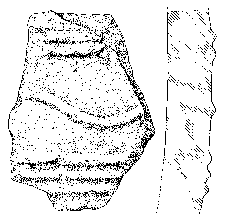
Figure 8. Archaic Pithos fragment from Area D.
In contrast the Hellenistic period well represented. Most material of this date comes from the edges of the Vadhiza valley along the spine of the ridges that border it, or from the slopes that face towards the center of valley. But there are more than 100 tracts in the entire area investigated by Team D that have yielded finds of the Hellenistic period. Site 020 is of particular interest since almost all of the surface finds there are of Hellenistic date. The site is situated in a small field that is intervisible not only with the whole Vadhiza valley, but also with the ridge of Cuka e Bukur and mali i Portë s. Deep ploughing of the field brought to the surface not only many tiles, bricks, and sherds, but also sandy stone blocks of different sizes, probably parts of a buried structure. Variations in the color of grass in the field gives indications of the extent of the structure. Analysis of air photographs could provide additional information. The large amounts of building material and the character of the pottery suggest that this site represents a small settlement.
Other sites produced Hellenistic finds together with Roman or later pottery: Sites 018, 019, 023, 029. Site 023 is located on a slope facing Vadhiza, where many residents of the village say that old houses of the village used to be located (although noone actually remembers a house standing there). Most of the finds from this site are concentrated around two rectangular features (about 60 x 55 cm each) which are not easy to interpret; they appear to be recent constructions. Hellenistic is the major component at this site (mostly tiles, amphoras, amphoriskoi and one black glaze skyphos); Roman finds include tile, plain red ware amphoras, and cooking ware). Ottoman glazed ware and a few modern tiles are also represented.
Site 029 is located in the same slope, but closer to Vadhiza and at a higher elevation. The site was not collected in 1999 but the substantial concentration of artifacts found during tract-walking included Roman plain ware amphoras, amphoriskoi, tiles, and cooking ware. Hellenistic is another strong component, including a late Classical/early Hellenistic black glazed krater, a black glazed skyphos, and plain ware amphoras, hydriae, and tiles. One Ottoman glazed bowl was also found. The site seems more likely to represent a small settlement site than a cemetery.
Hellenistic and Roman material is also found in large quantities at Site 019, together with a Medieval and Ottoman finds. This site is located on a slope by the Radostina-Shtyllas road and faces the valley southeast of Radostina. A density map of the site shows that finds are concentrated in a limited area and that tile is the most common artifact. A Middle and late Roman component is strong and is represented by plain ware amphoras, jugs, tiles, cooking ware, and an open shape in terra sigillata. A significant Hellenistic component is represented by many plain ware amphoriskoi, hydriae, amphoras, tiles, and fragments of cooking wares. Medieval combed ware, plain jugs and tiles, and Ottoman glazed jars, bowls, cups, and tiles are also found, but in smaller quantities. Finds from collection of the site have not yet been fully analyzed, but it can be already suggested that the site might have been a small settlement with one or two houses built of light materials.
Site 018 consists principally of late Byzantine, early Ottoman, and later Ottoman components. In contrast to the other sites it was located at the bottom of a small valley between the first two hills southeast of Radostina village. Four major ware categories (glazed, combed, plain, and cooking ware) are present in all main components (late Byzantine, early Ottoman, and Ottoman), but the range of shapes represented is quite different. While late Byzantine plain ware was used only for amphoras, in early Ottoman and Ottoman periods this category was also employed for the production of jars, jugs, tiles, and bricks. The same is true for the glazed ware: bowls and plates are the late Byzantine shapes, while in the early Ottoman and Ottoman periods we find bowls, plates, jars, jugs, cups, oinochoe, and vorbe. No doubt that the site was more heavily habitated in the Ottoman period than in late Byzantine times: these materials appear to be distributed in different parts of the site. A few Hellenistic and Roman tiles, bricks, and amphoras were also collected: Skë nder Mucaj suggests that these may have been brought to the site from elswhere and reused during the late Byzantine and Ottoman periods. Site 018 is probably a small settlement site with one or two houses of light construction.
Materials collected by Team D area this season give a complex picture. One Paleolithic site (024) and some isolated Middle Paleolithic points and flakes come from the southern and southeastern Radostina area. There is some indication of Upper Paleolithic presence in the Vadhiza valley, where there are also other less diagnostic prehistoric lithics. Indications of Neolithic occupation are present only in the southern end of the greater Vadhiza valley and at the adjacent northern end of the perroi i Levanit valley. Evidence for Archaic and Classical occupation in the area is scarce and present only in tracts that Team D surveyed in the main Apollonia necropolis area and in the Vadhiza valley. Roman settlement generally follows the lines of Hellenistic settlement in the area, but is on a smaller scale and less widely distributed. Only one site has produced Byzantine finds. On the other hand, Ottoman material was present in virtually the entire area surveyed, with major concentrations at Site 018 and near Site 019 in the southeastern Radostina unit, as well as in many parts of the greater Vadhiza valley. The major difference between the Hellenistic and Roman settlement pattern (Figure 9) and that of the Ottoman period (Figure 10) is that in the latter case, settlements were found not only on ridges and hill slopes, but also in the valleys. In all cases we are finding evidence left behind by rural communities whose main economical resource was the local environment. At some point these communities have been part of a greater economic zone built around Apollonia; exchange with Apollonia was a substantial part of their economy.
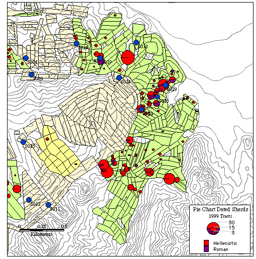
Figure 9. Distribution of Hellenistic and Roman finds in Area D.
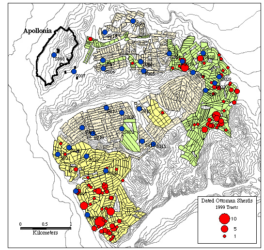
Figure 10. Distribution of Ottoman finds in Areas C and D.
Museum Operations[9]
The MRAP museum operation was under the direction of Sharon R. Stocker. Museum personnel in 1999 consisted of one part time and three full time staff members. The full time staff were Sharon Stocker and Jan Verstraete of the University of Cincinnati and Maria Grazia Amore from the Italian archaeological company, ERMA s.r.l. Skender Muç aj provided expertise in ceramic identification on a part time basis. The museum staff also included two photographers, Bonnie Beverage from Cincinnati and Nermine Më rtiri from the Institute of Archaeology in Tirana, and two artists, Jack L. Davis and Ilir Zaloshnja. Davis drew a total of 267 objects on 28 drawing sheets (to be inked electronically in England during the winter of 1999-2000). Zaloshnja spent the first three weeks of the season completing the challenging illustrations of lithics from the 1998 Paleolithic sites at Kryegjata A and B and spent the remainder of the season drawing more difficult ceramics and lithics found in 1999. He produced a total of 74 inked drawings. Muzafer Korkuti with assistance from Jim Newhard was responsible for an initial analysis of all lithic material brought in from the field, operating under the umbrella of the museum system.
Material was processed for a total of 22 days. During this time a total of 6200 fragments of ceramics and tiles passed through the museum for analysis (in 1998 the total was 2500). Over 2500 sherds were numbered and catalogued individually during the 1999 season, almost 1000 more than in 1998 (see Figure 11). Also, additional information including fabric descriptions, decoration and surface treatment was recorded for much of the 1998 material.
At the end of the work day all material brought in from the field was counted by a member of the museum staff with the assistance of a team member. At this time small finds such as lithics, glass, and bone, were separated from ceramic finds and brought into the museum. Ceramics were then washed by members of the teams that collected them. Once dry, the material was brought into the museum where it was sorted by unit into the categories fine or coarse ware, tile, lithic or other. The objects were then counted and weighed by category. After this point, sites and tracts were treated in different ways. Each item from every tract received a unique standard reference number that consisted of the team designation, tract number, and a sequence number within its lot. Basic information such as ware, shape, part , texture and date was then recorded for each sherd. Additional information about fabric, shape and decoration, dimensions, and Munsell color were recorded for items selected for drawing or photography.
| Pottery and Tile Count | Pottery and Tile Weight | Lithic Count | Lithic Weight | |
| Team C | 682 | 50 kg. | 85 | 4.0 kg. |
| Team D | 873 | 63 kg. | 76 | 1.0 kg. |
| Sites | 4566 | 21 kg. | 1054 | ĐĐĐĐĐĐ |
| Tracts | 1555 | 113 kg. | 161 | 5.0 kg. |
| Grand Total | 6121 | 322 kg. | 181 | ĐĐĐĐĐĐ |
Figure 11. Quantities of Artifacts Processed in 1999.
As in 1998 the majority of the ceramic material was dated to the Hellenistic period. This year, however, material from the Late Byzantine and Ottoman periods was more prevalent in tract collections (1998 tracts had 3 Ottoman and 61 Late Byzantine sherds; 1999 had 175 Ottoman and 52 Late Byzantine sherds. These periods were almost exclusively represented in the material from Site 018, which included plates, bowls and jars decorated with yellow, white, green and tan glazes, a pie crust plate rim decorated in green and white glaze, combed ware, and an exquisite sgraffito cup base with yellow glaze. Byzantine and Ottoman material was also present at sites 011 and 023.
Roman material was also more prevalent in 1999 than in 1998. Scatters of Roman material were collected at sites 011 and 012, which included a terra sigillata bowl base from 012, and high concentrations were found at sites 021 and 023. Site 023 included tiles and a combed ware sherd dated specifically to the Late Roman period.
Program for the Third Season
In 2000 fieldwork will be completed in the area of Apollonia and will expand for the first time into areas that may well not have been under control of the Greek colonists. Three regular archaeological survey teams will operate in the field: one team will complete survey of the Kryegjata valley, including fields around the temple of Shtyllas; a second will work in the area between the road leading from Qofa e Koshovicë s to Kreshpan and the ridge of Mt. Likovun; and a third will investigate the valley and slopes in the vicinity of Pluk, Kraps, and Lalar. The latter two areas probably lay within the territories of important Illyrian centers in the interior of Mallaskastra, such as Gur Zeze and Margelliç . The required digital maps (DEM) have already been prepared by Chris Dore of Archaeological Mapping Specialists. In addition to these projects, mapping of the cemeteries of Apollonia will be completed by a fourth small team, employing a Total Station as in 1999. Soil mapping of all surveyed areas will be initiated. Pollen cores will be extracted from the lagoon of Nartë and quantification of pollen from modern vegetation will continue.