A program of extensive walking directed at the examination of densely vegetated coastal areas located a site (Vromoneri Nozaina[I20]) of the third millennium, a period otherwise poorly represented in this part of Greece.
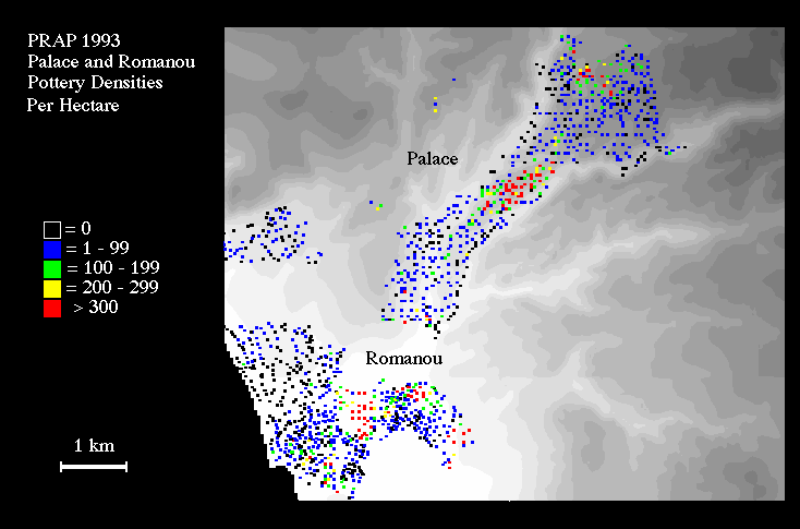
First, a 20-meter permanent grid was established by Professor Cooper and his University of Minnesota team along the Englianos Ridge from the Palace of Nestor to a point approximately 500 meters to the northeast. Surface artifacts in each of 180 20x20 m. grid squares were systematically collected with a view to refining still further our picture of the extent of the settlement surrounding the palace center throughout its history.
Second, several areas of high surface density were subsequently examined by magnetometry and geological coring (by Hans-Gunter Jansen [Tubingen] and by Zangger) in an attempt to discover if subsurface cultural deposits, perhaps even architectural remains, were intact. These investigations have unfortunately not yet produced evidence for extensive cultural deposits in situ beneath the plow zone. The construction of terraces for olive cultivation has done irreparable harm to the ancient site, as has continuous tilling of the soil, which has accelerated erosion of the soft marly soils and bedrock. Results on the citadel itself suggest that it is not a tell site, although it may have been leveled in the later Bronze Age before the final palace was constructed.
On the other hand, magnetometric prospection in cooperation with the University of Minnesota team, in unexcavated areas inside the archaeological site of the Palace of Nestor was successful in locating several new unexcavated buildings and walls, and in determining the exact course of the so-called aqueduct, parts of which had been excavated by Blegen northeast of the Palace.
As many as three new later Bronze Age sites were located in the course of intensive fieldwork, while a partial gridded collection was carried out at the known site of Gargalianoi Kanalos (shown here - site D1), with its possible prehistoric fortification wall and abundant material ranging from MH to LHIII (and beyond). Kanalos was clearly a site of considerable importance both in prehistoric and in later periods.
In the course of this fieldwork in and around Romanou, two remarkable new special finds were examined. In a field at the south side of the ancient site, an epistyle block from a monumental structure, perhaps a tomb, was located. In addition, at the north end of the site, a possible cemetery of chamber tombs was brought to our attention by Professor George Korres of the University of Athens and Mrs. Sophia Korre. Magnetometry was successful in locating what appears to be the preserved dromos for one of these tombs.
Another noteworthy discovery in the area was a very dense and rich scatter of material quite near the coast at Romanou Bouka (Site E1). The site appears to date to the Hellenistic and Early Roman periods, and thus would have been occupied at the same time as the nearby major settlement of Romanou. The limited size of Bouka, together with its remarkable variety of fine ceramics, including Megarian bowls, suggests - at this point - that it was the isolated residence of a wealthy landowner and is an extremely interesting departure from our more usual settlement trends.
Particularly outstanding in the coastal region is the site at Marathopolis Dialiskari (Site G1), a settlement probably even more extensive than that at Romanou. Our preliminary study of material suggests that the major occupation of the site belongs to the Hellenistic through Roman period, with a substantial Middle Roman presence. There are many traces of ancient buildings here, including a section of a hypocaust for a Roman bath.
Several other constructions (including a mosaic floor of Roman date, wall foundations and salt working facilities) were noted but poorly documented by Valmin in the 1920s. We anticipate working at this site again in 1994, carrying out more refined surface collection, magnetometry, and assembling a proper topographical plan of all ancient remains. This program of work will be of considerable importance, given the present threat to the site from beach-front development.
Investigations within the transects between Romanou and Marathopolis therefore produced additional supporting documentation that a predominantly nucleated pattern of settlement was typical of historical Messenia. To account for this divergent Messenian settlement pattern, we are currently developing explanations in which historical and cultural factors peculiar to the region (for example, Spartan domination in the Archaic and Classical periods) play an important role.
The danger to sites from human activity were highlighted by geoarchaeological work at a number of possible burial "tumuli" and at the large Mycenaean site of Koryfasion Beylerbey (site I1) examined in 1992. Geomorphological reconnaissance indicates that the "tumuli" often consist of "leftover" stratified marl-bedrock, preserved as conspicuous knolls ca. 3-5 m. high, either because they contained graves or because they support trigonometric markers. One site (Pyrgaki Tsouka [Site I19]) - containing graves and surmounted by a trigonometric marker - was extensively bulldozed within days of being drawn and measured in 1993. At Beylerbey, magnetometry and coring by Jansen and Zangger demonstrated that, despite its impressive horizontal extent, the site consists of a thin veneer of plowed soil and artifacts resting on bedrock, the present deposits on the site probably representing the last visible stage - the lowest or the only layer of habitation.
Very preliminary results of Yazvenko's analyses of pollen preserved in cores extracted from the Osmanaga lagoon are shown on the pollen diagram illustrated here, on which the vertical scale represents depth - and thus time - and the horizontal scale the percentage of various pollen types. The core may be divided into three zones, which are visually observable and are confirmed by cluster analysis:
Thus far, we have been successful in obtaining one 14-C determination at a depth of 105-110 cm. - the lower levels of Zone C, as indicated on the diagram. The uncalibrated determination is 1240 +/- 160 B.P., corresponding to a likely date somewhere between the fifth and seventh centuries A.D. More dates are, however, needed, as is a detailed analysis of a possible "hard water effect" on the organic material used for the determination. Nevertheless, this determination strongly suggests that zone B is likely to extend back into at least the later prehistoric period.
The GIS will also be essential to the analysis of off-site material as an indicator of rural space utilization. The large sample of Bronze Age lithics and ceramic material not directly associated with contemporaneous settlement will be particularly useful.
While straightforward visual presentation of these distributions plotted over the DEM is an important technique, more sophisticated analyses are also possible within the GIS. Among these are the identification of least-cost routes between sites - an important element in gaining a more sophisticated understanding of settlement location - and the creation of "view sheds" for the analysis of site intervisibility and interrelationships.
In addition to intensive survey and gridded collection at sites already defined, we will continue to document more fully those archaeological sites in southwest Messenia that are already known. Extensive survey for Paleolithic remains will be expanded.
In Spring 1994, specimens of vernal flora will be gathered. Geomorphological investigations will be continued in the area of the possible harbor, at the Palace of Nestor and in the vicinity of PRAP sites of all dates. A new and important aspect of environmental studies to be initiated in 1994 is the study, under Zangger's supervision, of soil structure and dynamics on a micro-regional scale by Mike Timpson, a professional soil scientist at Oak Ridge National Laboratory.
In conclusion, in its second season PRAP has added considerably to the results achieved in 1992. The documented prehistory of Messenia has been extended back to the Paleolithic/Mesolithic transition; a new third-millennium site and as many as three new sites of Mycenaean date have been defined. In the historical periods, results have been equally exciting: an entirely new site of Hellenistic and Early Roman date close to the coast west of Romanou; detailed collection of the extensive site at Romanou; the first systematic documentation of the extensive remains at the major Hellenistic-Roman site at Dialiskari and at the prehistoric and later site of Kanalos. In general, these results confirm the anomalous nature of settlement patterns in this region of Messenia, as opposed to those elsewhere in Greece: a difference that must now be accounted for. Finally, our program of geoarchaeological, palaeobotanical and now pedological studies are well on track to producing a complete and coherent picture of the environment in which humans lived in southwest Messenia from earliest times to the present.