Mallakastra Regional Archaeological Project
Third Season Preliminary Report
July 30, 2000
The third season of MRAP lasted from 16/6/00 until 30/7/2000. From 16/6 until 30/6, a small number of team members participated in the excavation of one of the concentrations of Paleolithic artifacts first identified in 1998 (Site 3, Kryegjata B) in the area of the cemeteries of Apollonia, on the outskirts of the modern village of Radostina. Under the supervision of John Whittaker (Grinell College, Iowa, USA), five one-square-meter trenches were excavated to a depth of approximately a meter. In several trenches levels with artifacts undisturbed by agricultural activities were discovered. The most diagnostic excavated lithic is of Upper Paleolithic date (see Whittaker’s report below). Also in the first two weeks of the season Sergei Yazvenko and Michael Timpson conducted paleoenvironmental research in the area of Apollonia. Timpson cooperated closely with Yazvenko in evaluating the suitability of local wetlands for the preservation of fossilized pollen and helped him to extract a eleven-meter-long core from a place near the monastery of Zvernec in the lagoon of Narta, northwest of the modern city of Vlora. In addition, Timpson assisted Whittaker in identifying and describing soils being excavated at Kryegjata B and mapped soil units elsewhere in the survey area (see his report below).
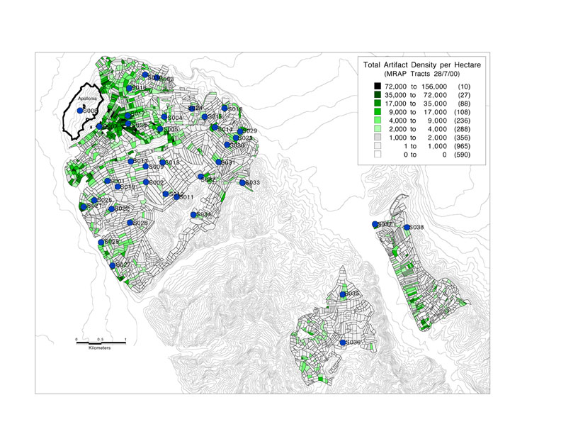
In the month of July, research focussed on intensive archaeological survey. Ca. 1600 new tracts were defined within an area of ca. 10.5 square km. that was intensively surveyed, bringing the total area walked in 1998-2000 to ca. 22 sq. km. (Figure 1).
Figure 1. All Sites Defined in 1998-2000 and Overall Artifact Density.
Twenty-one days were devoted to routine tractwalking and an additional three days were occupied in collecting sites (eight new sites were defined). One team led by Lorenc Bejko operated in the the valley of the Gjanice river around the hamlets of Plyk and Mbyet near Fier. Another, directed by Charles Watkinson, worked in the area of the village of Peshtan, south of the road linking Fier and Vlora, in the direction of Cakran. A third team, led by Aaron Wolpert , with assistance from Arta Mëhilli, completed survey of the entire Kryegjata valley, a project begun in 1998, and also examined the western slopes of the Shtyllas valley. In a very brief visit, Jan Driessen (Catholic University of Louvain, Belgium) was successful in taking a series of aerial photographs of the central part of the site of Apollonia, using a camera suspended from a kite, although work was hampered by the loss in transit of crucial parts of his equipment. Finally, Michael Galaty, assisted by James Newhard and Ben Witt, completed the production of the contour map of the nekropolis of Apollonia that had been started by Galaty and Newhard in 1999.
Principal discoveries in 2000 are summarized in the texts of individual researchers that are incorporated in this report but highlights may be emphasized here. Mapping of the nekropolis of Apollonia and the completion of intensive survey in the Kryegjata valley suggest that the densities of artifacts are significantly higher in the area of the nekropolis than in the area that lies between Kryegjata village and the temple of Shtyllas. No evidence was found that would suggest that there had existed a significant suburb of Apollonia there. Team J did not find remains of the Ionic temple near Kryegjata that was reported by Leake and other travellers in the early 19th century, but a well-bounded concentration of artifacts on the slopes east of Kryegjata village perhaps would repay further investigation. Survey by Team J also clarified somewhat the extent of distributions of earlier prehistoric finds in this valley. Another concentration of Paleolithic artifacts was identified on a hill immediately southwest of the site of Kryegjata B and it would now appear that most of the area of the Kryegjata valley between Kryegjata village and the village of Radostina was the locus of activities at this time. Finally, mapping of the cemetery itself has suggested that it includes approximately 100 burial mounds (tumuli) within an overall area of 20-25 ha. Many have been looted and the looting appears to be have continued in recent years at an accelerated pace.
In the first days of intensive survey, investigations by Teams F and H of areas near Levan that were left unexamined in 1999 by Teams C and D produced additional examples of small sites that are likely to be the remains of Hellenistic farmsteads and it now seems clear that the entirety of the uplands in the triangular area bounded by Apollonia in the west and Fier and Levan in the east had once supported such establishments. In contrast, however, in the vicinity of Peshtan and Plyk, east of Qofe Koshovicës, the situation appears to have differed substantially. Artifact densities, both tile and pottery, are significantly lower and the number of locations and sites at which Hellenistic artifacts were found are strikingly fewer (Figure 2). The sites that have produced Hellenistic remains deserve to be compared in detail to those farther west, perhaps by supplementing information from surface collections with the results of test excavations at several sites (e.g., Sites 34 and 37). Although interpretations must be extremely tentative in light of the small area that has thus far been investigated, it also appears that there may be differences in the character of prehistoric exploitation between the area around Apollonia and the valleys south of Qofe Koshovicës. Bronze Age artifacts, although not remarkably plentiful, appear to be rather more common and a significant concentration was defined (Site 38). In addition, it has been demonstrated that there are significant quantities of Paleolithic remains also to be found in this area (Site 36), as well as artifacts collected from tracts that appear to be earlier in date than any found in previous seasons. These discoveries should perhaps not come as a surprise considering Italian reports of Mousterian finds at Byllis that were published already in the early 1940s.
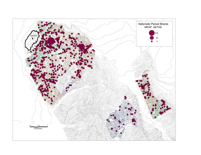
Figure 2. Distribution of Hellenistic Pottery in Entire Area Intensively Surveyed (1998-2000).
Test Excavations at Kryegjata B (Site 003) (John Whittaker)
The site of Kryegjata B was recognized by field walkers in 1998 as a scatter of flaked stone artifacts in a road cut toward the north end of the Kryegjata Valley, overlooking the villages of Radostina to the east and Havaleas to the west. In 1999 the surface of the road was gridded and systematically collected. More than 800 artifacts were found and it was decided that test excavations were desirable.
The goals of the test excavations were: 1) to understand site stratigraphy and geological relationships; 2) to collect a sample of artifacts; 3) to sample soils in order to determine if other classes of material are preserved; and 4) to assess the extent to which intact cultural deposits have survived and thus to determine the potential of the site for further investigation.
Site Setting
The site is located slightly below the crest of a rise overlooking the Seman River valley. The site’s location might have provided a slightly sheltered spot below the crest but one that was near a good observation point. Today it is cut by a dirt track which makes a "T" junction just north of the main scatter of artifacts. The road is deeply entrenched at this corner, but less so as it proceeds south through the area of the site. On the east side of the road is an olive grove, and, on the west, a vineyard; both sides of the road have ditches cut into the bank, with recent fencing bordering the fields. The vineyard is protected by a thorn hedge, and the olive grove by a cane fence put up last year, but both sides of the road have thick growths of brambles as well. Our expectation was that the artifacts in the road were primarily deflated from their original deposit, and were perhaps washed into the road from the fields as well, especially from the olive grove, which is up hill. As there were few artifacts on the surface in either field, despite plowing and other disturbances, it seemed likely that few artifacts are washing into the road from the fields, and that relatively undisturbed cultural deposits might lie beneath the plow zone.
The excavation test trenches were located with the local conditions in mind. The deep cut of the road at the northeast end of the site provided a convenient scarp section that could be inspected for geological purposes in a location where we seemed likely to be outside the boundaries of the site proper. For comparison with it, Trench 1 was dug to provide a second scarp, revealed under more controlled conditions, closer to the zone where artifacts were collected in the road, but still outside the probable site. Trenches 3 and 4 were excavated inside the fence at the edge of the olive grove, but close to the fence line where it seemed likely that recent agricultural disturbance would be minimized, and where a relatively undisturbed soil profile and site stratigraphy could be obtained. Later, Trench 5 was opened several meters further into the olive grove, to see if a cultural horizon was likely to be preserved under the disturbance produced by modern cultivation. Trench 2 was opened farther south along the road in the direction of the location where the denser concentration of surface artifacts was collected, and in the bank along the roadside where again it seemed likely that some intact deposits might have been preserved. Trench 6 was the designation assigned to the recovery of a skull fragment, probably recent, from the southern scarp of the road cut at the north edge of the olive grove.
Excavation Procedure
The five trenches were excavated by teams of two or three people, depending on labor available on any given day. Participating in the excavation were Maria Grazia Amore, Lorenc Bejko, Jack Davis, Blerina Dode, Michael Galaty, Sindorella Golemi, Muzafer Korkuti, Arta Mëhilli, Jim Newhard, Sharon Stocker, Mike Timpson, and John Whittaker. Each trench was one meter square. We attempted to dig by natural strata where possible, and 5 cm. horizontal "Collection Units" (Cus) were used to subdivide natural strata. Where no natural stratigraphic change was detected, excavation proceeded in 5 cm. CUs to maintain vertical control. After the completion of excavation, these 5 cm. CUs were correlated with visible stratigraphy and soil morphology.
We dug with small tools, and all excavated fill was passed through 7mm. (1/4 inch) mesh screens. We attempted to find artifacts in situ and record the provenance of individual finds, using both a total station and plotting on graph paper. The soil, however, was extremely hard and dry, often with a high clay content that made it difficult to excavate both rapidly and with care. As our goal was to test stratigraphy, and since our time was limited, we had to work quickly and some of the recovered flakes have damage from picks and trowels. In addition to the routine screening, a number of bags of soil were collected from CUs that produced lithic artifacts and were washed through 2 mm. mesh geological sieves. Only a few small flakes were recovered, but these tests served mostly to assure us that we were not missing small artifacts such as microlithic tools.
A few other samples were collected during excavation. The soil that was water sieved was also subjected to a simple flotation procedure, using water in a bucket and a fine mesh dipper, to see if carbonized plant remains could be recovered. A few flecks of charcoal were observed in the process. We suspect that this material is likely to be recent, since even where plowing has not disturbed the soil, roots and cracks have probably introduced modern material, as evidenced by the discovery of occasional finds of wire and pottery in the cultural horizon together with much older stone tools. A few charcoal flecks were recovered in excavation as well. The samples from the lowest excavated CU in Trench 4 (S003-04T-014-004, 005) appear to be the best material from which to acquire a C14 date.
Soil profiles and site geology were described by Michael Timpson and at the end of excavation, samples for thermoluminescence dating were collected from the geological section and from Trench 3. Sedimentological specimens were collected from columns in the west profiles of Trenches 2, 3, 4, and 5. Two samples of soil for pollen were taken from Trench 3 ( the EB, and the A5 horizons), but the prognosis for pollen analysis is not considered good because of the potential for intrusive material, and because of dry and abrasive conditions that are not conducive for the preservation of pollen.
Site Stratigraphy
The stratigraphy and soils of Kryegjata B are described in more detail by Michael Timpson (see his separate report below), and only a brief summary is given here. The site area is overlain by a sandy loam A horizon, which has been more or less disturbed by plowing and other recent human and biological activity. In our excavations we found few artifacts in this horizon. Under the A horizon is a B horizon, containing more clay; it is redder in color in the north part of the site and sandier and yellower in the south part of the site. Timpson regards this soil as having formed in sediments of Pliocene age. Soil development suggests as much as 80,000 to 100,000 years of weathering. The artifacts that we found in excavation appear to be concentrated at the top of the B horizon, in a zone that we regarded during excavation as transitional between the dark sandy loam of the A horizon and the yellower clays of the B horizon. The A horizon (above a prehistoric land surface at this level) was probably formed by the addition of wind-borne particles. Artifacts continued to be found well into the B horizon clays, in levels that we expected to be sterile. These may be moving into the deposit along root channels and down soil cracks; both phenomena were observed during excavation.
01T. Trench 1 was north of the concentration of artifacts collected in the road, and produced almost no artifacts during excavation. We cut into the top of the bank above the road to obtain a profile comparable to one around the corner that had been prepared by Timpson (see above), and to test whether at this point we were, in fact, outside the limits of the area of the site proper. The upper levels (Ap1 and Ap2 horizons, CUs 002-005) were a zone where an A horizon loam had obviously been mixed with yellow clays from below. Below this was a thick relatively undisturbed A horizon, followed by the transition to the subsoil B horizon, which here was redder and contained more clay than elsewhere.
02T. Trench 2 was placed along the edge of the road, further south into the area surface collections had yielded the highest density of artifacts. It would have been desirable to open another test trench still farther south but time did not permit it. The excavation of Trench 2 was complicated by a pre-existing ditch that had been cut into the area of the east half of the trench, and the A horizon also appeared to be truncated by an earthen path trodden alongside the road. The transition under the A horizon (BA and Bt1, CUs 8 to 13) was relatively thick, and was followed by a very hard clayey Bt2. Most artifacts were in the Bt1 transition, but lithics continued to be recovered until the end of the excavation more than 30 cm below it.
03T. Trench 3 was located on the edge of the olive grove on the other side of the fence at the east of the road. We chose this location in order to test deposits on this side of the road, but set it close to the fence where plowing and planting might not have been so intensive. Still, in this trench, as in all those that we opened in the olive grove, plow furrows were visible on the surface. Trench 3 also had a series of mixed A horizons (Ap1, Ap2, Ap3, Ap4, CUs 002-013), which imitated the lower soil profile, with dark loam above, and lighter transitional material in a lower layer. These mixed horizons contained quite a few artifacts, including the most diagnostic found in the entire excavation: a retouched Upper Paleolithic blade. It appears that this material was thrown up when the ditch along the road was dug. Under the disturbed A horizons was a less disturbed A5 followed by EB and Bt1 horizons, here relatively yellow. At the last excavated level (CU20 in Bt1), at a depth of nearly 80 cm, we were still recovering artifacts, but they were few; since we also found there a small piece of rusted wire, we suspect that this zone is culturally sterile except for artifacts derived from higher levels. Starting at the level of Ap1 and continuing into the less disturbed A5 as far as CU 016 we recognized a major tree disturbance as a dark stain occupying the center of the trench, but not appearing on the profile. In the upper levels, the disturbance consisted voids and soft spots with rotting tree bark, and was excavated as a separate CU 009. At lower levels, it was not possible to separate this disturbance from the surrounding fill.
04T. Trench 4 was placed one meter to the south of Trench 3, to produce a longer section in this place. It was slightly further from the road and the surface of the trench apparently did not recceive the overburden of material dug from the ditch. Two disturbed A horizon levels included a visible plow furrow on the surface and in profile, running north to south. Few artifacts were recovered in the less disturbed A3 (CU s 008-010), but they became noticeably more common in the transitional BA and Bt1 horizons (CU s 011-014) and were still being found at the end of excavation. It is thus possible that we have not completely reached sterile soil at this point, although as elsewhere, it appeared that we had penetrated into a zone which we would have expected to be sterile.
05T. Trench 5 was placed 3 m. east of Trench 4 to test conditions in an area that was further away from the road in the olive grove. In the 50 cm. of depth excavated, the stratigraphy was simpler than in other trenches. A disturbed Ap topsoil (CU s 002-007) overlay a less disturbed A (CU s 008-009 and 005). There was little cultural material in this soil. The transitional AB and Bt1 which followed it contained a number of flint flakes. Cultural material was still being recovered at the end of excavations, but the Bt1 was a sandy clay loam with gravel inclusions, suggesting, as elsewhere that it had been laid down before humans were present in this landscape. Artifacts found in this stratum probably derive from the AB horizon above.
06T. Trench 6 was not a normal excavation trench, but rather a designation assigned to the location where a skull fragment was observed by Muzafer Korkuti eroding out of the road bank some 10 m. north and 40 m. east of the main excavation areas. Because there seemed to be a possibility that the skull might be ancient, we decided to collect and record it. Korkuti and Lorenc Bejko removed it in a small block of soil. The bone was a vault fragment about 10 cm. by 10 cm., including a suture, and is probably part of the parietals with coronal suture. It has been fragmented into a dozen or so small chunks, probably the result of disturbance from traffic along the road. Preservation is good; the bone is chalky and white, but hard, and shows no signs of mineralization. My initial assessment is that the bone is not ancient, for a number of reasons. 1) The preservation is too good — we have seen no vestige of bone in any of the excavations, and Timpson expects the soils to be acidic and not likely to preserve bone. 2 ) The stratigraphic position was ambiguous, but the bone appeared to be lying flat, inner face uppermost, near the contact between the reddish subsoil B horizon and dark loamy topsoil. Directly in and on the bone was the dark loam. However, the topsoil material is visibly washing down from the bank and olive grove above, and the bone probably comes from there. 3) In the olive grove, a further 20 m. or so east of the find spot, is a single stone, apparently the headstone of a Moslem grave; it is thus likely that there were recent burials in the vicinity, although no other bone was observed.
Lithic Assemblages
The lithic assemblages from the road and excavations have not yet been thoroughly analyzed, but from my own observations and those of Muzafer Korkuti a few suggestions can be offered.
The collections made in the road include specimens of a number of different ages. There is one fragment of a leaf-shaped biface, usually considered late Middle Paleolithic in age, and a number of small Levallois flakes. The process of identifying these artifacts is complicated somewhat by the nature of the local raw material–small cobbles. Attempts to remove a large flake from these often produces the kind of preparation characteristic of Levallois industries, and similarly, Levallois flakes on such small materials can be seen as an attempt to make the largest possible flake from a small core. Although most of the lithic material has a relatively fresh appearance, some pieces are more heavily patinated or weathered. The excavations did not produce anything distinctively Middle Paleolithic.
Later blade-based industries are also represented. The most distinctive tool from the road collections is a short segment of a prismatic blade on which steep retouch along both edges has been employed to produce a double side scraper. A similar piece, the worked edges of which converge to a point, comes from the mixed upper levels of Trench 3. There are also several other pieces of prismatic blades, some fairly large and Upper Paleolithic in form, and others quite small and more typically Mesolithic. No microliths were recovered in excavation, despite care in screening, but one piece from the road is a short segment of a small blade retouched at both truncations to a narrow trapezoidal form. Korkuti feels that this is not a typical piece. Where platforms could be observed on blades, they were always plain and showed a marked point of impact typical of a hard hammer percussion blow. As well as a few definite blades, there are also some pieces of debitage which are typical of the kind of material produced in making blades. Small short flakes with parallel flake scars originating from a common platform are often produced in maintaining the necessary scar pattern on a blade core, and as the result of mistakes. In the early stages of preparing a blade core from the small cobbles available here, I would expect a lot of flakes with one cortical edge and one sharp edge formed by a previous flake scar, resembling the naturally backed knives of French paleolithic typology. These are in fact common in the assemblages, but would result from many operations on small nodules as well as blade cores, so there significance is not entirely clear. A couple of blade segments from the road are sufficiently large and regular to suggest they were struck from a larger core than most found at the site. Large blades require extensive core preparation on sizable nodules as well as being long themselves.
By far the most common artifacts found both in the road and in the excavation derive from the manufacture of small flakes from small pieces of raw material, a process I would expect to be common during all periods of occupation. Most of the raw material appears to be small cobbles of predominantly brown or honey colored flint. The two colors appear to grade into one another, and there are banded, grey, and red varieties that also seem to be part of the same basic lithology. These were all probably collected locally and are still to be found in roads and gravel quarrys, and on exposures on slopes and drainages. The nodules are typically less than 10 cm. in their largest dimension, and very rarely more. The quality of the stone grades from extremely fine to coarse and crystalline, and most nodules have a heavily rolled and battered exterior, suggesting that their original bedrock sources are at some distance. The majority of flakes, and all the cores I have seen, suggest fairly intense exploitation of these rather mediocre raw materials. The flakes mostly have simple plain or cortical platforms, although a few are facettted, especially the larger flakes that may represent Levallois technique. The cores are flaked opportunistically, with little platform preparation, and flakes struck in many directions. Most cores are small and pretty well exhausted, and a number of cores show crushed and stepped platforms, or multiple incipient cones on platforms, suggesting that reduction was carried on as far a possible, and sometimes even beyond reasonable expectations. The small size of the raw material is also reflected in the high percentage of flakes with cortex.
Conclusions
Unfortunately, we were unable to identify a stable prehistoric surface with artifacts in situ on it, or to recover a large sample of diagnostic tools. However, we can offer some preliminary thoughts on the potential of the site, and future analyses of artifacts will also be useful here.
There does seem to be the potential for the presence of further cultural deposits, relatively well preserved under modern topsoil and agricultural disturbances. The olive grove does not appear to have been as deeply plowed as feared, since there is a lower A horizon that appears unmixed with lower clays in all three trenches that were opened east of the fence. The transition horizons where most of the artifacts appear is probably not heavily damaged. However, the presence of fresh roots and rootlets, and occasional finds of sherds and metal even quite deep in the excavations suggest that soil processes have introduced some mixing. Where the orientation of flakes was observed, it was rarely flat — most were lying on edge or slanted, as might be expected of material in motion in soil cracks, for instance, rather than artifacts on intact surfaces.
There were some areas that were not sufficiently tested. Trench 1 shows that little material can be expected at the north end of the site, north of Trenches 3 and 4. We do not yet have a good idea of the other boundaries of the cultural material, nor can we say whether material from different periods can be expected to be in the same parts of the site. The denser surface collections were made on the road slightly farther to the south than the areas where we excavated, and it is possible that trenches set near the road farther south would produce larger quantities of finds. We also did not test west of the road in the vineyard, but there are almost no artifacts to be seen on the surface there, and the topography suggests that artifacts are more likely to derive from the east than the west (see the drainage model map prepared by John Wallrodt but not here included). It is possible that the road itself cut through the densest deposits. In Trench 3, this is suggested by the relatively rich deposit of mixed material which apparently came from digging the ditch closer to the road. It is also possible that there is a Middle Paleolithic level below anything we excavated, but Timpson considers this unlikely given the origins of the parent soil materials.
Preservation of material other than stone tools appears unlikely. No bone was seen, and there was little in the way of carbonized material. The samples from Trench 4 should be analyzed to see if they are old — if so, there may be other datable carbon. No concentrations of carbon were observed that suggest hearths or large amounts of relevant carbonized organic remains. Pollen samples also will be tested, although the potential for preservation is not good. No bone or other material at all was found in excavation. The samples taken for thermoluminescence dating should give us a better idea of the chronological depth of the site.
Further work on this site could involve further stratigraphic testing, and a wider areal excavation of any denser areas found, to provide a more comprehensive sample of stone tools from stratigraphic contexts and the possibility of associating them with absolute dates.
Geosciences Report (Sergei Yazvenko and M.J. Timpson)
Paleoecological Research
An 11-meter core was extracted from Narta Lagoon in ca. 60 cm. of water approximately 150 m. offshore from the coast of the small island of Zvernec, near the city of Vlora. The lowest meter contained material highly suitable for dating by 14C methods and dates derived from organic matter collected from two locations in the lower 0.50 m of the core should provide a terminus post quem for the entire sequence. Additional samples of organic remains, shell, and sediment for bulk dating were collected throughout the core. These should provide good temporal control for the calculation of sedimentation rates and for determining when changes in pollen zones occurred Samples of modern shell and marine plants (Rupia sp. and two different species of green algae) were collected for d 13C isotope analyses. These data will be used for comparison with d 13C measurements made on the samples collected for carbon dating throughout the core.
Additional test-coring was conducted in the marsh of Roskovec, southeast of Fier. The marsh consists of a large wetland complex with open-water, floating mat peat, and saturated mineral soils. We collected three test cores from the floating mat portion of the marsh. Core A consisted of approximately 0.30 m of mineral sediment from the base of the marsh. This material will be examined for pollen content and possible 14C dating of the bulk sediments. The peat deposits in this wetland could not be sampled this year because we did not have the proper coring equipment to sample this type of material. Core B was located ca. 20 m. southeast of Core A and consisted of 48 cm. of mineral sediment from the upper portion of the marsh bottom. This core will also be examined for pollen yield and for materials that may be dated by 14C methods. Core C (50 m. west of Core B) was the longest obtained from Rostovec (0.90 m). This core contained a 14 cm. thick lens of fibric peat near its center. The peat will provide material suitable for conventional 14C dating. The sediment above and below the peat lens consisted of gray, silty clays. Because of the length of Core C and the high quality dating material it contains, most analytical effort will be focused on this core. If Roskovec yields sufficient pollen and an interpretable date, further coring using appropriate equipment may be conducted during the 2001 field season.
Test coring was also conducted in the Mbrostar basin near Fier. This former wetland complex has been drained for agriculture by a series of open ditches up to 1.5 m deep. We used a Dutch soil auger to examine the upper 1.5 m. of drained sediments. This material consisted of stiff, gray silty clay, the presence of which indicates initial deposition in a reducing, quiet-water environment. The original sedimentary environment would have been ideal for pollen preservation and deposition, but in its drained condition, the upper 1.5 to 2 m. of the core may only yield highly oxidized pollen (if any remains). To investigate sediments deeper than 1.5 m. we moved east and drilled an auger core in the base of one of the drainage ditches. The ditch contained no water at the time we examined it. Its bottom is located approximately 1.3 m. below the present land surface and was probably 0.20 m. deeper when the ditch was first excavated. Sediments beneath the bottom of the ditch consisted of more stiff, gray silty clay. These were moist, but not saturated, throughout the additional 1.5 m. we examined. Four small samples (5 cm. thick) were collected at levels between 1.2 and 1.5 m. below the ditch bottom. These will be analyzed for pollen content and degree of preservation. We also collected a small (250 cm.3) sample of the bulk sediment for 14C dating. If the pollen yield and preservation are adequate and the 14C date is not too recent (e.g., < 500 years), further investigation of this basin may be warranted. Should we decide to pursue additional research at Mbrostar we will need to utilize a different coring device, as the Livingston corer is not rugged enough to retrieve a core in these dense, high-clay sediments.
Geoarchaeology at Kryegjata B
As a part of the archaeological test excavations at Kryegjata B, a soil profile / sediment column representative of the landform on which the site is located was described and sampled from a roadcut exposure. Samples of soil for thermoluminescence (TL) dating were also collected from this exposure. The TL samples were collected from three locations within the soil: near the surface (A horizon), mid-profile (Bt horizon), and from the deeper subsoil (BCt horizon). Dr. Glenn Berger, director of the geochronology laboratory at the Desert Research Institute (Reno, Nevada, USA) will conduct the TL dating analyses.
An initial site stratigraphy was developed from the sampled geologic section and by examining a 1.5 m. deep auger core located approximately 20 m. southeast of the roadcut exposure. Both soils contain an A horizon that is 30 to 50 cm. thick and that is underlain by an argillic B-horizon. The B horizon extends to a depth of 1.6 m. The soil that underlies the area covered by the test trenches is moderately well drained. The B-horizon is marked by mixed color patterns that are owed to redox depletions and redox concentrations; indicating temporary, seasonal groundwater saturation. Much of the site area is plowed to a depth of up to 40 cm., so artifacts recovered from above this level are certain to be out of primary context. Test Trenches 3, 4, and 5 all contained an intact A-horizon material below the plow zone. Trenches 2, 3, 4, and 5 also contained an intact transitional AB, BA, or EB horizons, implying that cultural material recovered from the subsoil may have contextual integrity. Pedoturbation processes (shrink-swell) have likely displaced some artifacts recovered from the lower portions of each test trench. Soils at the site and across the region exhibit extensive surface cracking. The cracks range from small (< 1 cm wide) to large (2-4+ cm. wide) and form owing to a combination of very dry summer conditions and the mineralogical composition of the soil clay fraction. The small number of test trenches excavated at the site makes it difficult to determine if the artifacts recovered from the lowest parts of each trench are a result of vertical displacement by shrink-swell processes or represent an in situ cultural deposit; they probably represent a combination of primary deposition and post-depositional reorganization. A larger excavation that provides a broader view of the lateral and vertical stratigraphy is required to separate these two processes.
Sediments in Test Trenches 2, 3, 4, and 5 were described and sampled after excavation was concluded. These samples will be analyzed for particle-size distribution, organic carbon content and pH. Data from these analyses will allow cross comparisons among strata in adjacent trenches and with the upper parts of the geological section. One TL sample was collected from the undisturbed A-horizon (A5) in Trench 3 (0.40-m below the surface). The date obtained from this stratigraphic layer will be compared with the date obtained from the equivalent A-horizon in the geological profile to determine if these strata represent the same geomorphic surface.
Additional Investigations at Localities Where There Are Paleolithic Surface Finds
Soils at Kryegjata-C were examined from a 1.2 m. deep auger boring located near the upper limit of the site area. The soil developed on this slope is morphologically similar to the soil underlying Kryegjata-B, but has developed from finer-textured parent sediments (possibly marl). The upper 50 cm. consisted of brown [7.5YR 4/4 (moist)] silt loam. The next 60 cm. of the core consisted of reddish brown [5YR 4/4 (moist)] silty clay loam. This argillic B-horizon (zone of clay accumulation) contained moderately thick, discontinuous clay films on ped faces. The last 12 cm. of the core contained a weakly developed Bk horizon (accumulation of secondary calcium carbonate). The carbonates occurred as soft concretions in a weakly- to non-calcareous matrix. Deeper boring would likely expose a more highly developed calcic horizon.
The upper 50 cm. of this soil may represent an aggrading surface resulting from periodic slope-wash from higher lying areas. No artifacts were recovered from the auger core, but approximately 5 m. down-slope from the core location, a small erosional scarp cut into the same micro-landform as the core, contained a tile fragment and two lithic artifacts within the upper 15 cm. of soil. Samples from the core were collected by soil horizon for physical and chemical analyses.
One additional soil profile typical of the red-beds associated with Paleolithic artifacts was described and sampled in a gravel quarry above the village of Radostina. This soil is morphologically identical to the profile sampled at Kryegjata-B and will be used as a comparative sample. A TL sample from the Bt 3 horizon of this soil will be dated for age comparison, as these soils should represent contemporaneous geomorphic surfaces.
The A-horizon was dark reddish brown [5YR 3/3 (moist)] sandy loam 30 cm. thick and contained approximately 2 percent small rounded pebbles. The argillic horizon (Bt) extended from 30 to 131 cm. This consisted of three parts, distinguishable on the basis of soil structure and clay film abundance and thickness. The Bt1 horizon extended from 30 to 62 cm, the Bt2 from 62 to 98 cm. and the Bt3 from 98 to 131 cm. Clay films were most abundant in the Bt1 and decreased in thickness and quantity with depth. Throughout the argillic horizon, skeletal grains were bridged by clay. Clay content was highest in the Bt1 horizon (a red [2.5YR 4/6 (moist)] sandy clay loam) and decreased with depth. The Bt2 was a yellowish red [5YR 5/4 (moist)] sandy clay loam. The Bt3 consisted of brown [7.5YR 5/4 (moist)] sandy loam. The sediment below the Bt3 has been minimally altered to form a Bw (cambic) horizon. This consisted of 21 cm. of sandy, matrix-supported coarse fragments (40 - 50%) of mixed lithology, dominated by limestones. The interstices were filled with coarse and medium sands. This horizon was not calcareous. No colors were described for this horizon because they would only represent the color of the primary sand grains. The base of the exposure (152 to 210 cm. +) consisted of clast-supported pebble to cobble-sized rock fragments (60 - 80% clasts). The interstices of these were completely filled by secondary calcium carbonate (Bk horizon). The calcic material extended an unknown depth below the base of the profile. Deeper exposures within the quarry imply that this material may be over 2 m. thick. The upper portions of the Bk horizon probably reflect a dominance of pedogenic (soil derived) carbonate redeposited from the overlying sediment during soil formation. Carbonate deposits in the highest part of the horizon were soft and friable and became more indurated with depth. The lower portions of the material probably reflect a combination of carbonate deposition through vertical leaching owing to pedogenic processes and to the flow of lateral groundwater through the deposit. Samples were collected from the portion of the horizon where pedogenic deposition appears to dominate.
Soil and Geologic Mapping in the Apollonia-Kryegjata-Shtyllas Area.
Soil and geologic exposures were examined along the east slope of the Apollonia ridge and within the Kryegjata valley and ridge area. Using the 1:10,000 scale topographic map as a base, a meander transect was walked and tape-recorded field notes were collected describing the bedrock, soils, and accompanying vegetation at each transect stop. Stop-locations were marked on the base map for future reference. The field notes will be combined with information drawn from the 1:25,000 scale geologic maps of the project area and the project’s DEM for analysis using the Spatial Analyst extension of ArcView. This procedure will yield slope class maps and water flow and accumulation maps that will be used to assist in mapping the soils near Apollonia. Similar computer analyses will be performed for the Shtyllas valley and ridge and the area around Shtyllas-Jaroi. Pertinent bedrock and soil exposures in these areas will be recorded during the 2001 field season so that soil mapping in these areas can be completed. The same approach will be followed in the Fier - Kraps and Peshtan - Bregas - Kreshpan areas that are currently being surveyed. Ultimately, both soil and geologic data will be helpful in interpreting the context of the archaeological survey data. Soils data will also provide some insight into past agricultural potentials of soils in all parts of the survey area.
Shtyllas Wetland Investigations
Samples of modern wetland plants collected from a small side-hill wetland on the west- facing slope of the Shtyllas ridge will be identified by the Yazvenko. The plant samples will be split and a portion will be used for taxonomic identification. The remainder will be analyzed for phytolith content so as to permit the creation of a preliminary comparative collection of phytoliths derived from modern hydrophytic plant communities. In addition, a short soil core was augered and examined in the field. The wetland soil is composed of fine-textured silty clay material, likely derived from marl-bedrock. The soil was calcareous (containing secondary calcium carbonate) to the surface, indicating carbonate deposition from evaporation of shallow groundwater and some groundwater discharge during winter and spring periods when groundwater levels are recharged. The high pH environment (pH 7.8 to 8.2 based on the presence of carbonate) is not favorable for phytolith preservation. The silica composing these plant parts is relatively soluble under these pH conditions, but one soil sample was collected to assess the presence and degree of preservation of phytoliths. Dr. Amy Ollendorf will analyze the phytoliths in the US. She has extensive experience analyzing phytoliths from Mediterranean wetland flora. Due to the extremely dry conditions in June and July the soils surrounding the wetland were too hard to conduct auger core transects. If a coring program to examine the historic extent of this wetland is conducted, it will need to occur in May when soil moisture conditions are conducive to this type of sampling.
Electronic Mapping in the Nekropolis of Apollonia and Elsewhere (Michael L. Galaty)
Objectives
In 1999, an Electronic Distance Measuring instrument (EDM; a.k.a. "Total Station") was brought into the field. It was used primarily to map portions of the Apollonia nekropolis and to facilitate surface collection of the Kryegjata B site in advance of excavation. These tasks were continued and concluded in 2000.
As described previously (see MRAP’s 1999 field report), mapping of Apollonia's nekropolis was deemed necessary and desirable for two primary reasons, leading to two different objectives:
1) The nekropolis is a very significant archaeological monument that currently suffers various threats (e.g., from looting, erosion as a result of army trenching and over-grazing, etc.) and requires conservation and protection. An accurate map allows creation of a management plan and the solicitation of outside funding in support of the implementation of such a plan;
and
The first of these objectives is still a real concern and now, having completed the map, the second may be seriously pursued.
Nekropolis
In 1999, the so-called "Archaic" nekropolis (surveyed in intensive fieldwalking in 1998 as Tract B057) was mapped (employing 3049 separate topographic points) and twenty-one tumuli were identified. Tract B057 would serve as an ideal location for the implentation of a third phase of research, where this desirable in the future: viz., the systematic intensive surface collection of finds from individual tumuli and associated robbed graves.
Mapping of Apollonia’s primary nekropolis was completed in 2000. 6492 topographic points were recorded (Figure 5). The cemetery appears to extend approximately 800 meters, beginning in a terraced farm field at the western end of the ridge on which it is situated. It is bounded to the north by the Përroi Vajës, which, along with a field road, has cut through several tumuli, and to the south by the dirt/gravel road that runs from Radostina via Kryegjata to Apollonia and the monastery of Shën Mri (Figure 6). As with Tract B057, mapping of the primary nekropolis has defined mounds and mound-like. Next year, we will endeavor to identify those that are tumuli for certain. At this point, it is our impression that the number of tumuli in the whole of the nekropolis does not exceed one hundred.
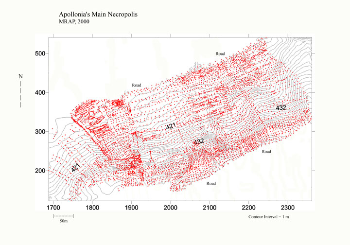
Figure 5. Main Nekropolis of Apollonia. Topographic Points.
We also mapped a subsidiary part of the primary nekropolis that is located to the south, above the abandoned military installation at Kryegjata (Figure 7). A tumulus in this area was surface collected in 1998 as S006. 565 topographic points were recorded. The tumuli in this portion of Apollonia’s nekropolis have been severely damaged by army trenching, bunker emplacement, and what appears to be fairly systematic looting of tile and brick graves and sarcophagi. For example, in some instances robbed graves have been backfilled, presumably in an attempt by the looters to cover their tracks. As a result of the damage to this portion of the nekropolis, plotting of individual tumuli in 2001 will likely be quite difficult.
Looting in other portions of the nekropolis continues to do irreparable damage, despite regular patrols by armed guards stationed at Apollonia. Many tile and pithos graves in the primary nekropolis appear to have been quite recently robbed (within the last few years) and, most disturbingly, a tile grave in a large, intact tumulus located in the "Archaic" nekropolis was robbed within the last year.
<
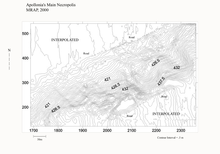
Figure 6. Main Nekropolis. Contour Map.
During the fall of 2000, high quality, publishable maps of the necropolis will be produced. These maps will include terrain features, such as bunkers, roads, power lines, trenches, etc., as well as those robbed graves that were located and recorded in the process of surveying. In 2001, individual tumuli will be identified and plotted on the final maps, as has already been done for the "Archaic" nekropolis.
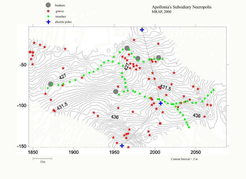
Figure 7. Map of Subsidiary Nekropolis.
Kryegjata B
In 1999, the Total Station was employed at the Kryegjata B site (S003) to construct a topographic map and to aid in surface collection of artifacts (see our 1999 field report). This surface collection identified a zone where artifacts were concentrated and thus helped to guide test excavations of the site in 2000 (see above). Additional data collected in 2000 using the Total Station further allowed a 3-D hydrological map of the site to be built in "Surfer." This map was instrumental in demonstrating the routes through which artifacts continue through erosion to enter the bed of the field road that cuts through the site.
S034
S034 is a large scatter of tile and pottery, presumably Hellenistic in date, discovered by Team H in the Levan valley at the beginning of the 2000 field season. Surface remains at the site were collected over the course of two days on July 22 and 25. Because the site appears a plausible candidate for future excavation, the Total Station was used to construct a 10 x 10 m. collection grid. If the "Station Point" (N = 1000, E = 1000, El = 50) and "Backsight" (1006.384, 1000, 49.485) can be relocated, excavation data can be integrated with those from surface collection.
We are now in a position to accurately plot all tumuli on high resolution topographical maps in 2001. This will allow individual tumuli to be systematically classified and surface finds from them to be collected. The final product will be a gazetteer of all of Apollonia’s extant tumuli. We may then take action to protect the nekropolis more effectively, and will be in a better position to elicit scientifically meaningful information from the burial monuments.
Team F (Charles Watkinson)
In 2000 Team F surveyed an area of 3.5 square kms broken up into 433 tracts. In the first week of fieldwork we worked with Team H to complete an area of north-facing slopes in the Shaban valley continuing from where Team C ended in 1999. As in 1999 a low background scatter of Hellenistic material contrasted with denser concentrations at the head of this valley (such as Sites 32 and 34). In contrast to 1999, however, a pattern of small lithic concentrations on the low ridges immediately overlooking Perroi Levanit was detected. This is perhaps worthy of further study. In succeeding weeks of fieldwork Team F focused on a new area (the Peshtan valley) and participated in the collection of a number of sites: The preliminary results from Sites 31 and 33 are described below.
The Peshtan valley is bounded by a high ridge to the east (along which runs the modern road to Cakran) and a slightly lower range of hills to the west. The modern settlements of Peshtan and Bregasi nestle high up in these western hills and the road which joins them formed one of our boundaries. During the season we gradually worked south between the Cakran and Peshtani roads, starting from a ‘V’ junction at the top of the valley, and working across a series of ridges as the valley gradually widened.
The broad-backed ridges that descend from the Cakran road, and the narrower, lower ridges around Peshtan form the major topographical feature of this well-watered and fertile valley. It was slightly below the tops of these ridges, where soil has washed down, that most traces of human activity in this valley were discovered.
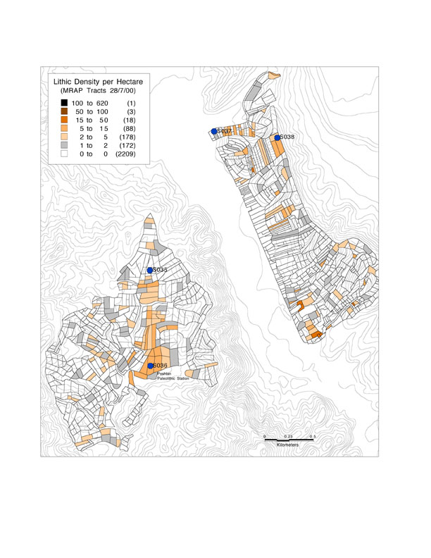
Figure 8. Lithic Distribution in Area F.
Strong evidence for Middle and Upper Paleolithic activity in the Peshtan valley now exists. Lithic densities on the ridges along the eastern side of the valley increased as we proceeded south culminating in densities comparable to those found in the Kryegjata valley in 1998 (Figure 8). At Site 36 a large number of flakes and cores reflect both Middle and Upper Paleolithic processing activity. The poor quality of the chert used, and the easy availability of large chert cobbles on the slopes above, may indicate that local raw materials were being used. The "Peshtan station" is of wider theoretical interest because of its location inland, away from views of the coastal plain, and its strategic position roughly midway between Kryegjata and Cakran.
No ceramic evidence for later prehistoric activity was uncovered (in contrast to Team H) but the isolated find of a blue-stone axe of a similar form to artifacts found during excavations at Cakran further suggests links to this important Neolithic site less than 15 kms to the south.
Divided from Apollonia by high ridges, and invisible from the city, Team F worked for the first time beyond the Hellenistic center’s hinterland. While the density of Hellenistic material was low compared to previous seasons’ work, it is perhaps significant that we found any material at all. Furthermore, although no densities were sufficient to be called "sites" there is some evidence for patterning in Hellenistic ceramics beyond the customary background scatter.
Large Hellenistic tile fragments as well as other ceramics were found at both Kodra Argile above modern Peshtan Shtanasi (site of the now-destroyed church of Shën Athanase), and in the area near Kodra i Nikonit on the opposite side of the valley. There were more diffuse scatters in adjoining tracts at the north end of the valley (Tracts F-025, F-026 and F-028) and on a couple of the ridges descending from the Cakran road (Tracts F-067, F-069, F-071 and F-083, F-084, F-345 and F-349).
Our "star find" of the season was also Hellenistic, but presents something of a puzzle. This was an almost complete Hellenistic amphora (Figure 9) not recovered during survey, but given to us by Aslan Shahaj, a farmer living on the end of the Peshtan Shahaj ridge about 1 km. east of Peshtan Shtanasi. He had uncovered the pot, full of sand but complete with a lid, while digging his garden about 10 years ago. During survey we found no Hellenistic material around his house (Tract F-298) and at present we have no further clues to the history of this isolated piece.
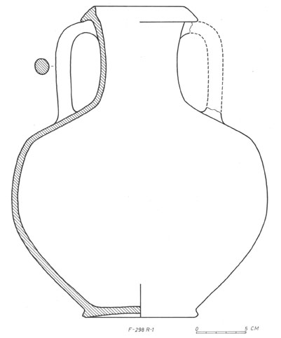
Figure 9. Hellenistic Amphora (F-298 R-1).
Although Sites 031 and 033 are several kms. north of Peshtan, their location and character shed an interesting light on the Hellenistic discoveries in our valley. Full analysis of the ceramics discovered is yet to be carried out but preliminary analysis suggests that both sites are small, single-period rural settlements. High up on ridges (Site 031 above the Shtyllas valley, Site 033 above the Levan valley) they both display high inter-visibility with other Hellenistic sites, and ceramic finds seem highly standardized and tied into a larger center (presumably Apollonia). An example of such standardization is a brick with an axe-shaped stamp found at Site 033.
As in the rest of our research area, Roman material seems almost lacking in the Peshtan valley. The much-disturbed remains of a 4th Century AD tile grave were pointed out to us by a number of local residents. High up on the edge of olives groves above and outside our western boundary, the site has been cut by construction work. No further analysis was attempted in 2000.
The richest period for ceramics discovered by Team F is that classified as Ottoman. A lack of stratified material published for this period complicates further definition, but some general patterns can be discerned.
A number of gray ceramics with deep combed decoration indicative of a Late Byzantine/Early Ottoman date were found just North of the modern village of Peshtan Shtanasi in a heavily eroded area below the main road (Tracts F-168, F-171 to F-175) and around the stream bed leading down into the valley (Tracts F-177 and F-201). They were also associated with a cemetery of weathered Ottoman gravestones, and the suggestions that the settlement of Shtanasi may (a) be at least 400 years old and (b) may have moved southwards in response to erosion seem reasonable.
Including Shtanasi (Tract F-172) we discovered four cemeteries with old headstones, some distant from modern settlement but associated with Early Modern ceramic scatters. These were in Tract F-338 on the Shahaj ridge, Tract F-161 on Bregu Rrapos and Tract F-372 on the other side of the valley below Kodra i Nikonit.
The impression of dense settlement in the valley during at least the Late Ottoman period was reinforced by interviews with local inhabitants, who gave us an extraordinarily warm welcome. The insights of villagers like Aslan Shahaj, Idriz Leras, Seit Cervenaku, Artani Duraj and Dino Azizi may occasionally have slowed our progress (especially when accompanied by gifts of watermelons) but immeasurably increased our understanding of the physical characteristics and recent history of the valley.
Change in the settlement pattern over the last 100 years, as reflected by densities of recent material in now uninhabited fields, seems to have been intense and rapid. While many exceptions undoubtedly exist, a general pattern seems to emerge:
While interesting in itself, the transformation in settlement pattern that has occurred over the last 100 years in the Peshtan valley is surely even more important as archaeological analogy. In response to various economic and political changes not only settlement but also the whole agricultural strategy has changed in a very short period of time. Areas of woodland marked on our maps from the 1980s have been transformed into intensively irrigated vegetable gardens. "Stalla" for cattle erected in the Communist period have either been destroyed (Tract F-423) or have been converted into storage areas for tomatoes and melons (Tract F-060).
What impact may further analysis of such radical recent changes have on our understanding of questions now being posed about, for example, the lack of Roman remains in the project area? Only further work in areas like the Peshtan valley will tell.
Team H (Lorenc Bejko)
Team H in 2000 surveyed an area of about 2.25 ha. divided into 358 tracts (an average size of 0.61 ha per tract). One of the subsidiary goals of team H this year was to continue the survey of the përroi I Levanit valley towards Levan from the place where team D stopped last year, meeting with team F which was progressing from the opposite direction. The main goal, however, was to survey a totally new area along the Gjanica valley to the southeast of Apollonia. Archaeological evidence for the use of this valley as an important route connecting Apollonia with the inland in antiquity already exists. Our systematic survey would throw more light, we believe, on the role that the valley played in different periods of antiquity. On the other hand, being further away from the immediate vicinity of Apollonia, we hoped to gain more information on the degree of land use and intensity of Classical and Hellenistic occupation. It was decided that team H would survey the area between the Fier-Kraps road and the long ridge that runs almost parallel to it and lies to the northeast of the road. We decided to take the Mbyet-Portëz road as our northern boundry. The general topography of the survey area is dominated by steep hills, mostly cultivated, which are divided by a number of small valleys. Between the main Plyk-Kraps road and the foot of the hills there is a narrow strip of flat fields that are intensively cultivated. The continuous ridge at the top of the hills is also an impressively flat area that makes it quite an attractive place for settlement. Valleys that run mostly northeast-southwest, create many small, well defined, individual units that we named according to the local toponomy or with reference to major topographical features, such as Hoxha's unit, përroi i Minës unit, Ferrkaj unit, and so on.
Important features of the area covered this year include small and big bunkers, abandoned military installations, destroyed buidings of the former collective farm system, eroded field roads (some of them are not identifiable on the ground), and badly damaged channels of the former drainage system. It seems that the individual family farms have only recently started to make visible infrastructural investments (mostly in vineyards). The cultivation of fields varies from vegetables to wheat and fodder. Almost half of the area is uncultivated or is covered by maquis; in these places the overall visibility about 28-30%.
Despite poor visibility, team H was able to locate five previously unknown sites, of which we collected two (another one was collected by team J). Finds collected in the entire area surveyed range in date from the Middle Paleolithic to Ottoman period, including the Late Bronze Age, Early Iron Age, Archaic, Classical, Hellenistic, Roman, Byzantine.
The most interesting lithics concentration in the area comes from tracts H—351 and H-352. The density of lithics per squared meter here is low, compared to all other Paleolithic sites identified so far around Kryegjata; some of the stone tools show unique typological features. The presence of large flakes and bifacial retouch is suggested by Professor Korkuti to represent an early phase of the middle Paleolithic if not a transitional phase from the lower to the middle Paleolithic. Types of stone tools include Mousterian points, a discoid scraper and a possible small hand axe (Figure 10). In the survey area in general we collected lithic artifacts from more than 28 tracts. No preliminary study of the lithics is yet available. However, it is interesting to note that another lithic concentration is associated with the tracts that comprise a late Bronze Age site (H-144, H-145).
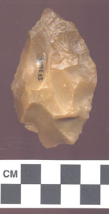
Figure 10. Possible Paleolithic Handaxe (SF 2687).
Team H identified and collected this late Bronze Age site (Site 38), which is located at the top of the hill overlooking village of Portëz. This site had already been visited many years ago by Neritan Ceka and Skënder Muçaj, and some diagnostic finds are published in an article in Iliria (Ceka 1990). From the tract walking as well as site collection a large number of sherds were collected, only few of which are diagnostic. Generally the ceramics are represented by plain ware, reddish brown in color, with many inclusions and with thick walls. Only a few sherds are black with a polished surface; these features, together with some small circular handles suggest the existence of a middle Bronze Age component at the site. However, the main component of the site dates to the late Bronze Age, a date that is also confirmed by the discovery of a small bronze dagger that seems to have been reused as a knife (Figure 11). Bronze Age material comes from 23 tracts in this area and all of it is plain ware. Shapes include cups, pitcher, bowls, mugs, trankards, as well as other open shapes. The distribution map in Figure 12 shows that, although Bronze Age finds come from many tracts, these tracts are all concentrated on both sides of the ridge that runs from the site to the valley. As we did not find any other concentration of finds other than at the LBA site, the finds in tracts represented the distribution map may be materials washed down from the site located at the top of hill.
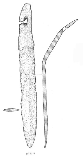
Figure 11. Bronze Dagger (SF 2713) from Site 038 (Portëz).
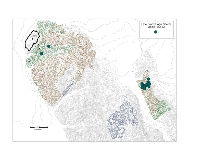
Figure 12. Late Bronze Age Pottery in the Entire Area Intensively Surveyed 1998-2000.
Other finds from a number of tracts can be identified as simply prehistoric sherds and no more precision is possible at this stage. However, there is one fragment of a plain bowl from tract H-241 that might belong to the early Iron Age.
Archaic and Classical finds are very rare. We have only two possible examples of Archaic pottery: one black glazed dinos from tract H-120 and a black glazed amphora from tract H-150. Classical pottery is somewhat better represented. It includes plain and black glazed amphorae, a black glazed skyphos, probably a dinos, and tiles. Archaic material comes from only two tracts; ceramics dated to the Classical period comes from more than 8 tracts. There is no doubt that the Hellenistic period is the best represented in the area we surveyed along the Gjanica valley. Hellenistic pottery comes from more than 60 tracts, but this figure is 40% smaller than the number of tracts that yielded Hellenistic pottery in team D's area last year.
In the Levan valley we found and collected a very rich Hellenistic site (S034) with very high concentrations of tiles and ceramics. Its location near the head of the Levan valley and its thick archaeological deposits make this site an attractive place to conduct a test excavation in order to gain more information on the chronology and organization of rural Hellenistic households in the greater Apollonia area. On the basis of our site collection we think that there might be two separate concentrations of artifacts, one of which represents the house itself, while the other may be the remains of a cemetery related to the site, or even of a separate building that contained more fine ware than the other. In the Gjanica valley we identified Site 037 (collected by team J). It has a strong Hellenistic component. Although we found other clusters of Hellenistic artifacts in the valley, none were defined as sites. The distribution map in Figure 2 shows that Hellenistic finds tend to come from ridges or slopes facing the valley. Overall the Hellenistic pottery includes plain amphorae, amphoriskoi, olpe, a black glazed skyphos, a pelike, a hydria, cooking ware and many tiles. Thorough analyses of the Hellenistic pottery from this area would give more details of the degree of the cultural homogeneity between groups that settled the Gjanica valley and those who resided in the immediate vicinity of Apollonia in the Hellenistic period.
The Roman period is very poorly represented this year. The only evidence comes from two tile fragments and one plain amphora sherd that are found in just two tracts (H-186, H-203) and were dated to the late Roman period. The absence of Roman finds is significant and worth noting.
The Late Byzantine and early Ottoman periods are well represented with finds coming from more than 30 tracts. Site 037 located close to the bottom of the Gjanica valley; a late Byzantine settlement seems to have been established on top of the Hellenistic remains. Finds of this period that come from other tracts are not numerous enough nor sufficiently concentrated to be classified as sites and are in many cases mixed with Ottoman and medieval materials. Most of the ceramics were glazed, plain and combed wares, while shapes include amphorae, jars, jugs, bowls, pitchers. Ottoman finds are quite defused and come from more than 50 tracts. No concentration of Ottoman finds was defined as a site because finds were not sufficiently numerous and are mixed with either Hellenistic or Byzantine pottery. It does seem likely, however, that if any Ottoman settlement is to be found, it will be located closer to the bottom of valley, not on hill tops as in the Late Bronze Age.
With the conclusion of the field season we have a quite complex view of the Gjanica valley. Paleolithic finds are very important as they represent early phases of the middle Paleolithic or the transition from the lower to the middle Paleolithic. The Late Bronze Age is well represented by an important site (with a metallic artifact on the surface) surrounded by smaller concentrations. Mycenaean finds from Margëlliç seem now less isolated than before. Archaic and Classical finds are very rare and sparse, as is the evidence for the Roman period, phenomena that need to be explained somehow. Hellenistic occupation of the area is much better represented even if it is less intense than that of the immediate vicinity of Apollonia. The Byzantine and Ottoman periods are again well represented, but we as yet lack firm evidence that would permit us to describe fully the settlement patterns that existed at these times.
Team J Report (Aaron Wolpert)
Team J worked in four topographic zones in the coastal foothills east and south of Fier in the 2000 field season, surveying primarily in the immediate hinterland of Manastir and moving on into the Gjanicë valley for the fourth week of fieldwork. Work started in the low hills south and west of Radostina Fasko, hills that stretch along the coastal plain (marked by the Vjosë-Levan-Fier canal as it runs past north Pojan and Havaleas) up to the northeast end of the ridge on which the acropolis of Apollonia is situated. This first topographic zone consists of low hills and ridges bisected by the northern end of the përroi that runs past the acropolis and through the village of Kryegjata on its way out into the coastal plain south of Pojan Sopi. The second zone surveyed stretches from the lower slopes of the acropolis just north of the përroi Kryegjatës across the valley bottom south to the Shtyllas ridge, covering the south side of the Kryegjata valley from its southwest end at the coastal plain north of Shtyllas village northeast to k. Kripës. Cultivation divides this zone further into the valley bottom, ridge slopes west and south of Kryegjata, and rougher terrain northeast of the village. Cut straw and fallow open pastureland is predominant on the southern ridge slope, with mixed cultivation in the well-watered bottom land. Past the low ridge that descends from the northern end of Boka e Madhe toward an abandoned military complex, however, the sharper relief and more folded terrain is now covered in low oak macquis and has suffered serious erosion in recent years. An area on the other side of the ridge separating Kryegjata from Shtyllas comprises the third topographic zone covered. Stretching from the head of the Shtyllas valley down to the east edge of the village, this zone covers the steep southern face of the ridge and the broadening bottom land north of the dirt road that runs the length of the valley — this road runs along the south bank of the përroi Shtyllasit from its origin at a spring-fed pond midway along the valley. Tracts walked in this zone stretched around the southern end of the Shtyllas ridge and up over the prominence on which a Greek temple stood in antiquity. During the last week of fieldwalking, Team J moved to the Gjanicë valley in the vicinity of Kraps Stane and Plyk Bogdaraj. From a field road that runs just south of the prominent stream channel that divides Kraps Stane northward to the sharp fold that splits Qofe Labit, tracts on the east side of the valley covered two major descending ridges (Kodra Goxheles and the southern spur of Qofe Labit) as well as the intervening folds in the topography — almost all of this area was under cultivation and it is not divisible into discrete subunits.
In the zones that wrap around the northern and eastern sides of the acropolis ridge, the objective was not so much the identification of discrete "sites" in this immediate hinterland of Apollonia as much as a resolved picture of artifact density and temporal patterning. There is, as expected, a wide crescent of high-density surface remains within 200-800 m. of the acropolis walls, a steady background in which the "gaps" in the distribution are perhaps more important than prominent spikes for reconstructing the landscape history of the area. Diffused scatters such as this call for high resolution field walking — tracts follow field boundaries closely and are for the most part smaller than 0.5 ha — a strategy that has generated some more or less distinct scatters and has pointed out clear regions of low artifact densities that stand out from the general pattern. A second subsidiary objective specific to the second topographic zone was the delineation of boundaries and temporal resolution for the necropoleis southeast of Monastir, and for this purpose tiles and bricks (possibly indicative of Hellenistic vs. Roman graves) were counted separately throughout the survey area. In addition, for the necropolis area walkers were instructed to identify obvious exposed graves, information which was entered in the log book and recorded in the database in the "comments" field.
Radostina Fasko Zone
Fieldwork started on the hills outside Radostina Fasko and around Kodra Kutës and Kodra Ullirit, where fields that were unwalkable in 1998 (due to standing wheat) were revisited and the survey area expanded down toward the përroi Kryegjatës. Ceramic densities were rather low on the slopes just above Radostina Fasko but picked up noticeably on the slopes west of Kodra Ullirit as tracts J-035/046/047 covered the halo of Site 016. An unexpected development north of this halo on the other side of a significant fold in the topography was a significant lithic concentration in tracts J-076, J-077, J-081, and J-050. The most intense concentrations were localized on shallow washes where chert cobbles were exposed along with blade tools and debitage. That this material was exposed as close to the valley bottom as J-050 suggests significant downslope erosion and displacement. Lithic scatters in this zone were restricted to the Kodra Ullirit ridge and its slopes. West of the përroi on consecutive hillocks are perched the local cemeteries for Havaleas and Pojan, and on these coastal projections artifact counts for the "Greek" periods of habitation increase, although in neither location was the artifact density remarkable. Both locations yielded notable features, a large piece of Roman (?) grindstone northwest of the Havaleas cemetery and possible Hellenistic house foundations on a low ridge stretching toward Pojan from the front gate of the Shen Marina cemetery. The bronze serpent SF 1892 (Figure 11) was allegedly found on a slope east of Shen Marina, but the findspot area indicated did not turn up any notable concentrations, nor anything indicative of mortuary activity.
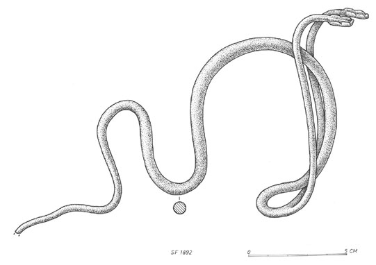
Figure 13. Bronze Serpent (SF 1897) Possibly from Shën Marina (SF 1892).
The fourth significant concentration in this zone was hardly surprising, a series of high-density artifact counts on a saddle just outside the northeast fortifications of the acropolis and smeared down over the north slope of the ridge down toward Pojan proper. Artifacts from this area were primarily of Hellenistic date, but J-119 produced sherds identified as Archaic as well — on this side of the ridge facing the coastal plain soil is composed of a light brown marl not as conspicuous on the other side of the ridge. Although this concentration is by no means surprising, an abandoned military base in the vicinity of Tracts J-162 and following has perhaps contributed to the artifact density; some structures are still standing and are reused as a house complex at present. For modern land use, variation in field size distinguished the area immediately behind Pojan quite clearly from the përroi Kryegjatës valley. Fields were rather smaller next to the village and were more elaborately fenced. According to Arta Mëhili, fencing was not just required for protection from animals but was installed as a marker of land that was among the first distributed following the collapse of the communist administration. Moreover, tractwalking in the përroi fields made it clear that fields were of very similar sizes, perhaps indicative of inheritance patterns that require equal distribution.
Kryegjata Zone
Artifact densities were consistently high and largely Hellenistic on the lower slopes of the acropolis and do not admit further speculation on concentrations and temporal patterning, with the exception of J-175 through J-177, where exceptionally high artifact counts are ‘distorted’ by the remains of a farmhouse recently destroyed (structures are depicted on the 1984 topographic map, but a local villager estimated that the complex was abandoned in the 1970s). What is interesting here is that finds from J-175/176 are registered as Ottoman, suggesting that the abandoned house was rather older than modern exile constructions or was placed on a long-inhabited farmstead. Though artifact densities do not fall of appreciably (nor probably with statistical significance), a fall-off does appear in the fields southwest of the rutted road that leads up over the acropolis ridge from Kryegjata. Localized erosional structures perhaps explain this pattern, as the slope to the acropolis is notably sharper northeast of the road and has produced spectacular erosion events like that evidenced by the large scar running downslope from the monastery and hastened by excavations of the ancient fortification wall here. In contrast, the ridge cline is rather less marked as the ridge descends toward the southwest and the isolated estate at the end of the përroi channel, perhaps resulting in less erosion and displacement. The tracts along the southern end of the përroi are also exclusively in the valley bottom, whereas fields farther up the valley occupy the bottom as well as the lower slope of the acropolis to the irrigation channel that marked the boundary here; extensive silting has apparently not occurred in this bottomland, however, if the tile grave reported in J-189 stands up to scrutiny. This grave was observed in a drainage channel not much more than one foot deep, neither buried by substantial erosional deposits nor washed down from the slopes itself — whether the tile arrangement is in fact a grave is somewhat questionable, however. In this context a more or less intact stone sarcophagus found in tract J-167 is relevant, a feature not much submerged in an alfalfa field and apparently not far relocated as three fragments of its lid were found nearby. Dating this sarcophagus was not possible, so its force in reconstructing erosional patterns over the past two millennia is debatable. On the other hand again, the markedly lower artifact densities on the south side of the përroi Kryegjatës could argue for more erosion on that side of the valley, where more intensive modern cultivation on the slopes behind Kryegjata has resulted in more erosion and therefore ancient artifacts interred in silt — that the slope is less sharp on the south side and not reserved as a cultural monument perhaps contributes to this pattern. However, as there was little recovered from any part of the Shtyllas ridge slope, it is plausible that there just was not much cultural material in this part of the zone in the first place. In fact, from the southwest edge of the village along the ridge toward the temple, there was a notable break in high-density scatters. Only on the saddle bridging the temple prominence and Kodra Shtyllasit was there a remarkable concentration: viz., J-229/230 — with Archaic through Hellenistic artifacts recovered on this rocky conglomerate waste. It is this eroded marginal surface that has perhaps produced much of this patterned absence of concentrations. Just where one might expect outlying Hellenistic farmsteads, on a ridgecrest clearly visible from the acropolis as with other sites in the survey area, extensive military construction and resultant erosion have stripped the ridge of its soil. And given the violence of the erosion instigated by the large bulldozed construction projects for bunker and artillery emplacements all along the ridge (erosion scars have deepened considerably in the interval between 1984 and the present as contours on the ground are noticeably different than those mapped; see the scars in front of the artillery emplacements in J-287 for an example), deflated sites with cultural material still in place are not likely.
Circumstances are very different on the section of the ridge that stretches from Boka e Madhe toward Kodra Kripës, where artifact counts returned to levels past soft background noise. Military construction was less intense along this stretch, and current cultivation is nonexistent. Not only did artifacts reappear along the crest, but there was substantial material collecting on the upper slopes on the north side of the ridge. And in the vicinity of Kodra Kripës there was an impressive broad concentration running down the ridge that extends northwest from the tumulus. That this scatter in tracts J-411 through J-416 was in fact spatially removed from the tumulus indicates a distinct feature — walkers in tract J-413 report high artifact counts on the ridge but markedly fewer remains on the saddle connecting it to the ridge. This concentration was associated with more foundations identified by Skender Mucaj and deserves closer inspection, as there was a huge quantity of material washed downslope on both faces of the ridge (sherds range in date from LCL/EHL through R). In any case, that remains are clustered at this point on the ridge could of course indicate a ‘real’ ancient feature that is different from anything else on the ridge to this point, but the correspondence of high densities with 1) relatively quiet military construction interference and 2) underdeveloped cultivation (for which distance from villages must contribute) cannot be discounted for the tracts draped over the ridge from the water pump station to Kodra Kripës. (Dispersed lithic finds were reported along this ridge as well, particularly in tracts J-410/412 as well as at the base of the knoll in J-407 .)
In any case, the expansive concentration along the necropolis ridges and down into the area surrounding Kryegjata marks an indisputable ancient presence. Tracts walked in the low macquis separating the Kodra Kripës ridge from the ridge that descends from the water pumping station were very effective in delineating necropolis boundaries. The presence of graves on the latter spur was already known, but how far the necropolis spilled into the intervening depression is now clearer. That surface remains are restricted to the ridge itself is clearly shown in tract density maps, where artifact densities drop off smoothly from the top of the ridge into the adjacent depression. Tracts J-362 through J-367 followed the ridge and established a clear boundary halfway down the southwest slope — walkers along the bottom of the adjacent ravine recovered very little cultural material. On the northeast side, there was a clear drop-off in artifacts on the far side of a deep wash marking the bottom of the ridge. Some material was recovered in the area along this wash, but the distribution changes considerably toward the east. Such a clear pattern could be deceptive, however, as erosion and looting complicate the picture. It is not immediately clear how recently this area was under cultivation, but field boundaries are preserved in varieties of macquis (tract J-381, for example, was covered in low macquis that did not include the oak species characteristic of the surrounding area and was set off by sharp rectangular boundaries). In any case this depression has not been recently ploughed and is not as susceptible to erosion as is the ridge; erosion exposes graves, exposed graves invite looting, and looting makes graves more visible on the surface. It is a remote possibility, then, that the absence of surface material in the depression speaks less to the distribution of graves on the necropolis as it does to the effects of erosion and subsequent direct human interference on the surface record.
The two primary necropolis ridges intersect near the abandoned military base, and it is in this area that the most impressive concentration of artifacts in the first two topographic zones was recorded. Interpreting the scatter is more difficult than identifying this convergence on the map. Clearly most of the lowland tracts surrounding the necropolis ridges contain primary mortuary material and/or erosional deposits, but the immediate Kryegjata environs are more problematic. There is some evidence that the necropolis extends some distance up a third ridge, the scarred spur that runs parallel to the necropolis covered by tracts J-362 through J-367 — a possible sarcophagus fragment was discovered in tract J-295 in a heavily eroded wash just under the steep west face of the spur, and artifact densities are high from that point downward. At the bottom of this slope and across the road from the military complex is a series of bottomland fields bounded by the road, a cross-valley drainage channel overgrown with bamboo, and the përroi Kryegjatës. Tract J-306 and adjacent fields in particular stood out with prominent concentrations; on walking these tracts it was not at all clear that they formed a unit with the necropoleis, yet on the map and from a distance the spatial connection is clearer. What functional and/or geomorphological connection exists is not able to be determined at present. Most ceramic fragments were small and abraded and were not concentrated in scatters directly indicative of graves. Complicating the issue is the fact that villagers informed us that Kryegjata was once rather larger, and there are several more house complexes on the 1984 map; late Byzantine, Ottoman, and modern sherds were mixed with Classical and Hellenistic sherds throughout the series J-293 through J-317, a crescent wrapping around the east and north sides of the village. An associated concentration continued on the other side of the village in tracts J-335 through J-343 — whether this scatter marks the location of the temple reported by Leake and other early nineteenth century travellers is of course unanswerable without more intensive investigation.
Shtyllas valley zone
Artifact distribution along the north slopes of the Shtyllas valley corresponded to the patterning reported for the south side of the valley in 1998-1999, with more discrete scatters marked off by intervening "gaps." Apart from a limited halo east of the village between the road and the përroi, there were only two major concentrations. The first was a rather large smear draped over a large prominence that extends from the sharp slopes south of Kodra Kripës down to the valley road (tracts J-439 through J-442 and J-475 through J-491) and along the road west toward the spring (tracts J-447 through J-450 and tract J-474). Although the sharp contour break between J-417/418/419 and this prominence separates the concentration from the tumulus complex above, several other factors complicate interpretation in advance of closer inspection. A military complex occupied the northern end of the hill from ca. 1971-1991, and remains are still clearly in evidence. The local tenant (a 70-year-old man from Radostina) informed us that his great-grandfather claimed that a church occupied the crown of the hill (in the vineyard walked as tract J-486). And nearly impassable macquis leaves the spatial connection between the scatter on the hillside and that on the lower terrace undetermined. Thus at this stage the most notable aspect for this site is the range of temporal components represented, from Archaic through late Byzantine; without further investigation the location of the alleged "church" and its relationship to more ancient remains is not capable of being determined.
That this concentration is located just about midway between Radostina, Kryegjata, and Shtyllas is perhaps significant, and has had modern implications in that the terracing that extends from the north end of the valley ends in tract J-248 and does not pick up again until tract J-472. The Radostina resident manages an impressive agricultural estate just on the edge of a long stretch of macquis and rugged slopes that clearly have not been cultivated recently — he quite likely occupies the most southern Radostina property in the valley. These latter terraces are remarkably empty of cultural remains — until they reach the vicinity of the temple, where densities pick up again. That much is not surprising, but the relatively "quiet" distribution on those terraces and across the temple platform is striking. Only one tract, the lower terrace in tract J-531, yielded a tile density in the 150-300 tiles/ha. range, and only two (J-531 and J-518 — the latter crosses over the temple itself and open excavation trenches) fall into the 20-30 sherds/ha. range. Moreover, some 82% of the diagnostic sherds recovered date to the late Byzantine/early Ottoman periods. The area certainly stands out as an anomalous concentration given the low background noise in the immediate vicinity, yet perhaps not with the intensity one might expect for a site with standing ancient architecture. The temple platform does not show evidence for recent cultivation, and the most intense concentrations (at least visually) are restricted to an eroded hollow between the two spurs that project out into the coastal plain toward the northwest. The only other notable concentration is a localized tile scatter within tract J-529 — Ottoman artifacts were identified from this tract, with others on this slope yielding only late Byzantine.
Kraps Stane Zone
The ridges and hollows above Kraps Stane are intensively cultivated, with viticulture currently popular on the whitish powdery soil that dominates here. Artifact concentrations were rather limited in this landscape, but three concentrations in particular deserve further attention. A remarkably dense lithic scatter was reported from tracts J-686/687, alongside a much-disturbed schoolyard and ridge crossed by roads and damaged by construction and demolition, such that its suitability for further investigation is likely limited. Along the top of the same ridge was another striking ceramic concentration, with tiles and pottery clustered in the southern end of tracts J-613/614 and in tracts J-619/621, just at the northern end of a long saddle between Kodra Goxhelës and Mali i Cukës. The steep but stable and micro-terraced ridges to the north enclosed fertile inter-ridge alluviations intensively cultivated but nearly devoid of artifacts. From this low background noise a few Archaic sherds stand out in tracts J-734/740, as well as scattered prehistoric sherds from the long open ridge leading toward Qofe Labit. On the last day of fieldwork a scattered concentration came to light on the interior slopes of the southern half of Qofe Labit in tracts J-766/770/771 — preliminary inspection suggests a mix of prehistoric and Ottoman sherds on the ploughed fallow fields in this broad ridgecrest swale. This possible prehistoric concentration along the ridge perhaps continues the pattern observed for the northern reaches of the ridge, with concentrations spaced along at higher elevations.
Museum Report (Sharon R. Stocker)
The MRAP museum operated for 26 days from June 29 until July 28. Full time staff members were Sharon Stocker, Jack Davis and Rita Vilvens. Sabina Veseli helped with the processing of material on a part time basis. Skender Mucaj, museum director for the Albanian team, was responsible for the preliminary analysis and dating of ceramics. Both Garrett Holden, the project photographer, and Ilir Zaloshnja, the project illustrator, operated in conjunction with the museum.
All finds brought in from the field were the responsibility of the museum staff. Material collected each day was entered into the museum system by a member of the museum staff upon each team’s return from the field. Ceramics and lithics were washed by field teams in the courtyard of the monastery (our sherd yard) each evening. The following day dry material was collected from drying screens and brought into the museum workroom for analysis. Objects from tracts were set out on worktables in sequential order by team, registered (counted and weighed), and separated into the categories of ceramics and small finds. Preliminary information about small finds, which included all non-ceramic objects as well as loom weights and spindle whorls, was recorded onto Small Finds forms for entry into the Small Finds database.
Information about the fabric, ware, form, vessel part and date of each sherd saved during tract walking was recorded on pre-printed carbon forms which were then passed on to the computer room for data entry. Artifacts deemed particularly diagnostic were sent out for photography and/or drawing. The scanning of artifacts directly into the computer was a method of visual recording first tried experimentally this year with great success.
Artifacts collected from 690 tracts (F: 219; H: 148; J: 323), which included 2042 sherds and 1157 small finds, were processed and catalogued during the 2000 season (Figures 14-16). Sites 028 and 029 collected during the 1999 season were also processed. Because of staff shortages in the museum, however, it was decided that further processing of site material would be delayed until the season in 2001.
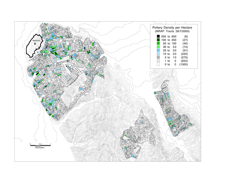
Figure 14. Distribution of Pottery in Entire Area Intensively Surveyed 1998-2000.
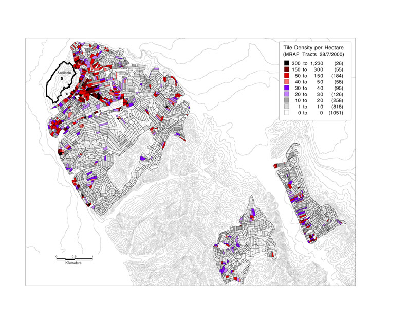
Figure 15. Distribution of Tile in Entire Area Intensively Surveyed 1998-2000.
Samples have been taken from 56 ceramics that have been identified as coming from Archaic Corinthian transport amphora. These samples will be exported from Albania and sent to the University of Cincinnati where petrographic analyses will be conducted by Dr. Craig Dietsch of the Geology department in collaboration with Mike Galaty and Sharon Stocker. Ian Whitbread of the Fitch Laboratory in Athens, who specializes in petrotgraphic analyses and has particular expertise with Corinthian amphora, has agreed to act as a consultant.
As in the past two seasons, finds of the Hellenistic period were predominant in all surveyed areas (Fig. 2). Fine Black Glaze pieces, many of which came from miniature vessels, were especially prevalent in the necropolis. Of note is a Late Classical/Early Hellenistic body sherd from a Black Glaze krater with Red Figure decoration (B-148R-03) of probable South Italian manufacture. The image on this krater shows Eros on the left facing a seated male figure naked to his hips on the right (Fig. 15). The bottom of the sherd has a palmette border with an acanthus band. Also exciting is a nearly complete Hellenistic amphoriskos of the late 3rd century B.C. that was brought to the museum by team F.
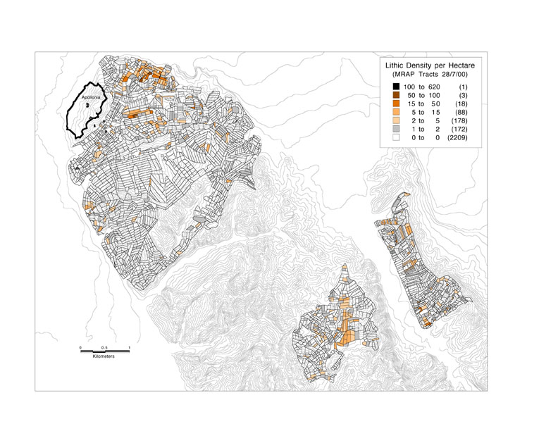
Figure 16. Distribution of Lithics in Entire Area Intensively Surveyed 1998-2000.
Artifacts dated to the Late Byzantine and/or Ottoman periods were also well represented in the 2000 ceramic assemblage. Most noticeably absent from the 2000 assemblage are finds from the Roman and Paleo-Christian periods. Only 18 objects dated to the Roman period have been identified, and only 2 of these 18, both of which come from the area of the Apollonia Necropolis, are fragments from Terra Sigillata bowls or plates, of types commonly found in surveys in Greece and Italy. No finds from Paleo-Christian/Early Byzantine periods are present in the 2000 ceramic assemblage.
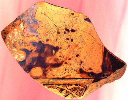
Figure 17. Rim Sherd from South Italian Red-figured Krater (B-148R-03).
The number of Archaic sherds (9) recovered at a distance from Apollonia is perhaps among the most surprising results of this year’s field work (Fig. 16).
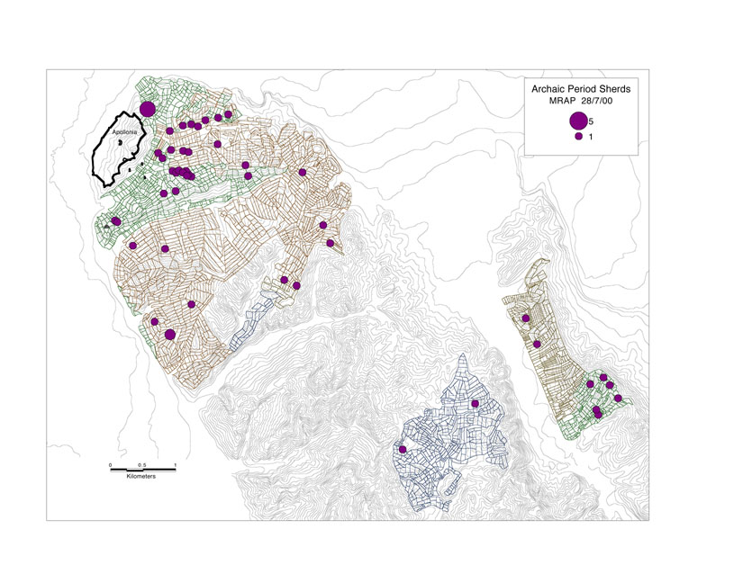
Figure 18. Distribution of Archaic Pottery in Entire Area Intensively Surveyed 1998-2000.
Gazetteer of Sites Defined in 2000
Site 030. Paleolithic. The highest concentration of lithics is in a shallow wash roughly at the junction of Tracts J-076 and J-077 on the second terrace down from bunkers and continuing onto the third terrace.
Site 031. Hellenistic. Tracts A-166 to A-168 and Tract D-275. 150 m. SE of Dushku Kuq on the ridge road from Radostina to Mali Portes. Owner of olive groves is Avni Bushi.
Site 032. Pottery not read. Directly southwest of Tracts D-329, D330, D-335 through D-338, and south of Tract A-202. A terraced prominence southwest of a road junction reaches from remains of bunkers on top of this ridge southeastward to the bottom of the valley. Terraces wrap around this gently sloping cline and are interrupted on the northeast and southwest by washes of moderate depth.
Site 033. Hellenistic. The site is on a ridge around 2 km. W of the Shtyllas/Radostina road junction. To the N there are good views to Fier. To the S are views down the Levan valley.
Site 034. Hellenistic. Located in the Perroi i Levanit Valley on a prominant ridge that extends almost from the road Vadhize -Levan to the bottom of the valley. The location of the site offers the possibility of control over the the Perroi i Levanit as well as a suitable settlement. The site is associated with tracts H-007 and H-008.
Site 035. Ottoman. ?Paleolithic. Toponym Peshtani Binjaket. In the Peshtani valley about 1 km. S of the Cakran/Peshtani road junction. A small knoll with 4-5 house complexes on it. Tracts F-043 to F-052.
Site 036. Tracts 223-227. A broad-saddled ridge extending W down from the Cakran road. To the S a high (c.120 m.) maquis covered ridge blocks the valley. Toponym is Sheshi i Gushallareve. Owner of fields is Rrapo Gusha.
Site 037. Pottery not read. Site occupies the end of a long steep prominence that runs at a right angle to the main north-south ridge that bounds the Gjanice valley on the east; just north of the site is a broad subsidiary valley that runs up over the ridge north of Portëz, and the Fier railway line runs just past the site on the west.
Site 038. Late Bronze Age. The site is located at the top of the hill with the electric power line piles on it to the southwest of Portëz. The small hill top is part of a long flat ridge that controls both the Gjanica valley (village of Mbyet) and the open lowland east of Portëz. The site center is not far from the place where the electric power line pylon is located. Site is associated with tracts H-143; H-144; H-145.